- Remove Small landforms filter Small landforms
- Remove Cultural landscapes filter Cultural landscapes
- Remove Ulvik filter Ulvik
- Remove Kvam filter Kvam
- Remove Voss, frå 2020 del av nye Voss herad. filter Voss, frå 2020 del av nye Voss herad.
- Remove Fusa, frå 2020 ein del av nye Bjørnafjorden kommune filter Fusa, frå 2020 ein del av nye Bjørnafjorden kommune
- Remove Road constructions filter Road constructions
- Remove Runestones filter Runestones
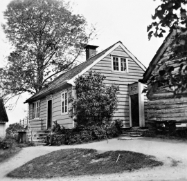
Øpstad
The post house at Øpstad stands out in the landscape. An ochre yellow house with a loft and a white-painted house in Swiss style with ochre edgings, bears witness to a well preserved house from the 1800s, nearest neighbour to the beautiful old vicarage. In the Øpstad hamlet there was a post office for more than a hundred years, until the 1970s. Today it is possible to walk the old post road across the mountain to Strandvik, as part of “Den Stavangerske Postvei” (The post road to Stavanger).
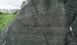
Vangdal
At Salthamaren in Vangdalsberget it is thought that salt was burned some time in history, and deep layers of coal in the ground show that fire has been made up here several times. But they were hardly salt-burners, the first people who stopped here. Some of them carved figures into the rock. On top of the rocky outcrop, furthest out on the cliff, a group of Stone Age hunters carved animal figures. More than 1,500 years later Bronze Age farmers drew ship figures at the foot of the rock. Both these works of art - some of the oldest in Hordaland – are still visible, carved in the rock at Salthamaren.

Ulvund
One of the oldest farms in Myrkdalen, Ulvund, is recognized as one of 14 areas in Hordaland having an especially valuable cultural landscape. The dirt road runs along a steep slope down toward Lake Myrkdalsvatnet. The flattest field, which today is harvested for silage, used to be an old grain field, while the slopes were old hayfields.

Tokagjelet
There is a sharp transition between the wide valley at Kvamskogen and the narrow Tokagjelet. The transition is no less dramatic when we come out of the crooked tunnels far down in the canyon, and the open Steinsdalen valley spreads out before us. The canyon both separates and joins together different epochs in western Norway's history.

Stalheimskleiva
From the oldest times on record in Norway one of the most important traffic arteries between west and east Norway has passed across Bolstad – Voss – Stalheim – Gudvangen and Lærdal. The post road between Oslo and Bergen was established here 1647, but in Stalheimskleiva there was only a packhorse track right up to the 1840s. Wheeled transport and carts were in little use in the mountains in West Norway up to that time.

Osa
At the bottom of the Osa fjord there is a cultural landscape marked by great contrasts; the wide terraces and the river delta at the fjord contrast with the steep hillsides in the background, where Norddalen leads up to the mountain. There are two farms here. Osa and Sævartveit – the farm at the river mouth and the hollow by the sea.

Nes
The farm Nes lies directly inside Mundheim on a forested headland in the fjord between Mundheimsvika and Bondesundet, a farm with an attractive and well-kept cultural landscape.

Jomfrunuten
Freezing and thawing are processes that influence plant cover, move enormous blocks, stretche long mounds of earth, break open bedrock and create patterns in stone and earth.

Holo
I Kvassdalen var det aktiv stølsdrift med mjølking av kyr og geitehald nokre år inn i vårt tusenår, og slik hadde det vore i meir enn to hundre år. Såleis har dalen ikkje fått gro til med kratt og skog, men er open og lys. Fortsett er det beiting av kyr og sauer.

