- Remove Small landforms filter Small landforms
- Remove Middle age filter Middle age
- Remove Maritime environments filter Maritime environments
- Remove Eidfjord filter Eidfjord
- Remove Modalen filter Modalen
- Remove Osterøy filter Osterøy
- Remove Glaciers filter Glaciers
- Remove Fusa, frå 2020 ein del av nye Bjørnafjorden kommune filter Fusa, frå 2020 ein del av nye Bjørnafjorden kommune
- Remove Trading posts and guesthouses filter Trading posts and guesthouses

Eikelandsosen
"So many and such big potholes as are found at Eikelandsosen, we don't see other places in western Norway, and as beautifully polished as the mountainside is along the river up to Koldal , one would look a long time to see anywhere else. There is much to dazzle a geologist's eyes. If only these features could bring others the same joy!"
Engevikhavn
The guesthouse activity in Engevik in the 1700s could not have been very extensive. But a hundred years later a trading and guesthouse centre developed on a piece of land called Engevikhavn. This is the place where Segelcke had obtained licence to operate an inn and guesthouse business in 1729.


Halne
At Halnefjorden, a few hundred metres east of Halne mountain lodge, lie the remains of two stone sheds – Halnelægeret. Some generations ago the cattle drovers stopped here in the summer; they were the cowboys of their time. But Halnelægeret already had a long history before the cattle drovers came.

Heggjagarden
The transport exchange on the farm Vik in Eidfjord was an important part of the communication network in older times. This is where people secured transport by boat out in the fjord, those travelling across the mountain from east and down into Måbødalen. The transport exchange was situated at “Wiige grund”. Today the highway cuts through the farmyard; the main farmhouse from the 1800s lies on the upper side of the road, the large sea-house, with a bakery in former times, lies close to the fjord.

Simadalen
On the 10th of August, 1937, over half of the agricultural land in Simadalen was submerged by the river. The damage to roads and houses was also catastrophic. This was the most destructive flood ever recorded in Hordaland.

Nottveit
In one of the frame-built haysheds at Nottveit, at holding No. 3, we discover that several of the staves have a medieval look, with large dimensions and carefully rounded edges. According to tradition, it was the farms Nottveit and Mostraumen that supplied the timber for the stave church at Mo, and it is not unlikely that these farms received the old timber in return when the new church was erected there in 1593.

Otterstad
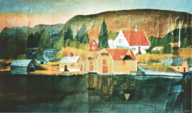
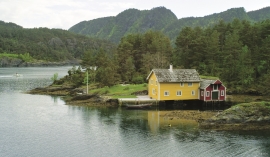
Tthe Otterstad farms lie in the innermost part of Mofjorden, on the northwest side of the river. The row of stave-built boatsheds that belong to the farm were probably constructed a little after the middle of the 1800s. Both here and on the Mo side, the boatsheds were important storage places at the seashore; wood and other farm products intended for the town; corn and merchandise in return.

Mjøsvågen
Around Mjøsvågen here is still a compact marine use area. Some of the buildings are common boathouses, but most of them also house small enterprises and workshops. This is where the farmers from Øvsthus, Mjøs, Hole and other farms have supplemented their meagre incomes as smiths, brass moulders, clog makers, chest builders and decorative painters.

