- Remove Small landforms filter Small landforms
- Remove Middle age filter Middle age
- Remove Eidfjord filter Eidfjord
- Remove Wetland filter Wetland
- Remove Fedje filter Fedje
- Remove Granvin, frå 2020 del av nye Voss herad filter Granvin, frå 2020 del av nye Voss herad
- Remove Defense filter Defense

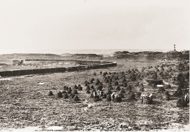
Halne
At Halnefjorden, a few hundred metres east of Halne mountain lodge, lie the remains of two stone sheds – Halnelægeret. Some generations ago the cattle drovers stopped here in the summer; they were the cowboys of their time. But Halnelægeret already had a long history before the cattle drovers came.

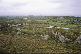
Langavassmyrane
The Ruff lek on Langvassmyrane is the only known phenomenon of its kind on Hardangervidda. Every year it attracts hens from the whole plateau. The marsh is also the richest wetland in the county. This green oasis is located in a rocky moraine landscape a few hours walking distance south of Dyranut.

Granvinsvassdraget
After the ice age, Granvin Fjord reached all the way up under Skjervsfjossen waterfall. Just a thousand years later, as a result of the rising of the land after the ice melted, this whole inner part of the fjord freed itself of the sea and became Granvinsvatnet lake. In spite of this rise in elevation, this waterway is still navigable for fish: Sea trout have wandered into Granvinsvatnet in more recent times and evolved to become freshwater trout. And salmon and sea trout made the journey 13 kilometres up the Storelvi river.

Fedje bog
The wild rabbit is really native to Northwest Africa, but the Ancient Romans introduced them to large parts of Europe. Not to Norway, rightly enough: the population on Fedje originated from 3-4 pairs that were brought here from the Shetland Isles in 1875, making this their first residence in the country.
Stormark
Both the climate and people have been decisive in shaping the bog landscape on Fedje - a landscape that has been evolving over several thousands of years. The peat got built up layer for layer and provided income and fuel for the people of Fedje.

Vinappen
Vinappen lies on a low hill to the very west on the island. Here you have an amazing panorama of the sea. Originally the area was grazing land for cattle, but this changed when the Germans occupied the island. Just before WWII there was a small bearing station, used by the Norwegian Coast Artillery in connection with exercises at sea.

Eidfjord church
The old stone church at Eidfjord has an open position on the terrace at Lægreid. In a diploma from 1310 it transpires that Torgeir on Sponheim donated a gift for the erection of the church in Eidfjord. Thus we can assume that the church was under construction at the time. The elements in the style confirm such a dating.

Øvre Folkedal
Folkedal, which today is like a small “detour” from the main highway, was in the Middle Ages centrally situated in one of the most important roads between Hardanger and Voss. This is the road that Olav Haraldsson travelled in 1023, when he came from the royal farm at Avaldsnes for a meeting with the Voss inhabitants about the new belief. The road passes across the mountain pasture Krossaset and down Bordalen to Vangen.

