- Remove Small landforms filter Small landforms
- Remove Middle age filter Middle age
- Remove Eidfjord filter Eidfjord
- Remove Stord filter Stord
- Remove Wetland filter Wetland
- Remove Place filter Place
- Remove Igneous rocks filter Igneous rocks
- Remove Sawmills filter Sawmills
- Remove Os, frå 2020 del av nye Bjørnafjorden kommune filter Os, frå 2020 del av nye Bjørnafjorden kommune

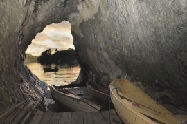
Halne
At Halnefjorden, a few hundred metres east of Halne mountain lodge, lie the remains of two stone sheds – Halnelægeret. Some generations ago the cattle drovers stopped here in the summer; they were the cowboys of their time. But Halnelægeret already had a long history before the cattle drovers came.

Langavassmyrane
The Ruff lek on Langvassmyrane is the only known phenomenon of its kind on Hardangervidda. Every year it attracts hens from the whole plateau. The marsh is also the richest wetland in the county. This green oasis is located in a rocky moraine landscape a few hours walking distance south of Dyranut.


Kattnakken–Stovegolvet
The highest mountainous area on Stord, including Kattnakken, Midtfjellet and Stovegolvet, has more in common with the mountainous terrain on the mainland than in the low coastal landscape of Sunnhordland. The volcanic bedrock together with the erosive powers of nature has resulted in a unique plateau landscape.

Sagvåg
The pit saw on the property of the farm Valvatna, is the origin of the name Sagvåg. The sawmill is mentioned as early as 1564. The name of the place at that time was Fuglesalt, but soon there is only talk of Saugvog.

Tveitavatnet
It is difficult to imagine that a plant can grow at the same place for many thousands of years: Climate and local environment change. Different species grow up and die out. Nonetheless, some plants get established, but don't manage to spread into new areas, because the climate is at the edge of what they can tolerate. Great fen-sedge is just such a plant.

Ådlandsstova
The Ådland house is one of the biggest medieval houses still existing in West Norway. It is constructed from unusually large, hard fir wood, beautifully oval-cut. One story links the cottage to the Gildeskålbakken at Orninggård (Lower Ådland); thus indicating that the cottage has been the medieval banqueting hall. The building has been dated back to the 13-1400s by carbon dating.

Ådlandsvatnet
Plants that grow in and beside water have to be prepared for marked and rapid changes in their living conditions. They must be able to tolerate living under water without drowning, and getting totally dried out without whithering. Many swamp plants are well adapted to these kinds of changes.