- Remove Small landforms filter Small landforms
- Remove Farm sites filter Farm sites
- Remove Sund, frå 2020 del av nye Øygarden kommune filter Sund, frå 2020 del av nye Øygarden kommune
- Remove Ulvik filter Ulvik
- Remove Samnanger filter Samnanger
- Remove Os, frå 2020 del av nye Bjørnafjorden kommune filter Os, frå 2020 del av nye Bjørnafjorden kommune

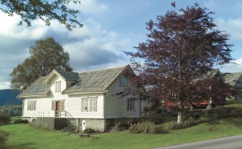
Frøystein
The farm Frøystein by the Ulvik fjord is commonly called Fryste. In 1614 the name was written Frøstemb – an obvious Danish influence – and the form Frøsten was used up until the land register in 1886 and 1907. It is probable that the name of the farm originally was Frystvin; a vin-name. Thus it has no connection with neither Frøy (Norse fertility god) nor stein (stone).

Jomfrunuten
Freezing and thawing are processes that influence plant cover, move enormous blocks, stretche long mounds of earth, break open bedrock and create patterns in stone and earth.

Fossen Bratte
The steep drop by Fossen cliff has been the biggest challenge for those who wished to make a road over Kvamskogen through the years. Leave the car by the monument on the old road and take a walk down to the bend by the waterfall that Bergen-folk call "The bridal veil". Why is there a waterfall just here?


Golta- Long house
In the years between the wars a major registration of houses and house costumes, house construction methods, fireplaces and forms of housing clusters was started in West Norway – an ambitious mapping of everything that came under the name “Registration of Culture and Geography in West Norway”. One of the places of which material was gathered in 1938 was an old multi-room house at Golta; new and interesting material for the researchers from the Historical Museum, but well known within the local building tradition through several generations.