- Remove Small landforms filter Small landforms
- Remove Maritime environments filter Maritime environments
- Remove Road constructions filter Road constructions
- Remove Bergen filter Bergen
- Remove Boat- and shipyards filter Boat- and shipyards
- Remove Factories filter Factories
- Remove Granvin, frå 2020 del av nye Voss herad filter Granvin, frå 2020 del av nye Voss herad
- Remove Archaeological findings filter Archaeological findings
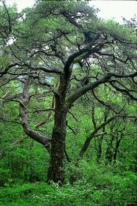
- Remove Coniferous forests filter Coniferous forests

Alvøen
Alvøen is one of the oldest industrial places in Norway. As early as the 1620s a gunpowder mill was built here. The place itself was well situated for industrial activity, lying only 100 m from the waterfall, which provided power for the mill, and a good harbour wherefrom the products were shipped. The success of the gun-powder mill varied in the 1600s and 1700s, but what made Alvøen best known was its paper production.


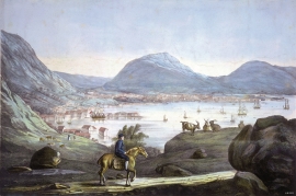
Lussand-roadwork
The road along the north side of the Hardanger fjord - between Øystese and Eide in Granvin – was literally built “by hand”. The construction work started in February 1933, and on 9 October 1937 Crown Price Olav opened the stretch of road between Øystese and Ålvik at Fyksesund bridge.
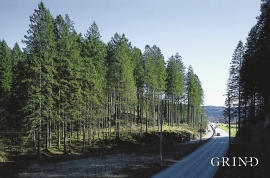
Rådalen
"...it would not be of any particular economical interest to support the planting of forest as the forest that can be cultivated will leave much to be desired in the way of growth potential." These words stem from the economist that at the end of the 1800s was sent to Stend to inspect the planned reforestation in person. The pioneer G.A.Wilson put the economist's words to shame. The spruce that was planted in Rådalen in the period 1867–1869 became a landmark. No other stand of forest in Scandinavia can boast more trees per unit area.

Salhus
Salhus has been a connecting point for sea travellers far back in time. The name probably derives from the Old Norse word sáluhús, “house for travellers”. The name may indicate that this was a place for an inn even in the Middle Ages. The place is eminently situated in the route to and from Bergen. For travellers coming by boat from Sogn and Nordhordland, Salhus is the last stop before Bergen. Travellers from the communities in Voss also came this way earlier when they were going to Bergen

Sandviken
Close to the tunnel opening at Amalie Skrams vei in Ssandviken, there is a cultural monument of European dimensions; a rope making works that produced rope and fishing tackle for West and North Norway.

