- Remove Small landforms filter Small landforms
- Remove Fisheries filter Fisheries
- Remove Late glacial filter Late glacial
- Remove Large landforms filter Large landforms
- Remove Bergen filter Bergen
- Remove Ulvik filter Ulvik
- Remove Pollution and environment filter Pollution and environment
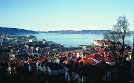
Byfjorden
Swimming and fishing is fully possible in Byfjorden (By Fjord). The water is of good quality most places, after considerable resources have been used in past years for clean-up. But, past sins still lie in the mud on the sea bottom. Fish that live in direct contact with the bottom sludge should not be eaten.

Nordåsvatnet
The Post-war Era came to Fana with its population growth and modern sanitary equipment. This had nearly catastrophic consequences for Nordåsvatnet as a recreational area. After the runoff water got re-directed to deeper water, and later also to the fjord outside, Lake Nordås won back both its swimming guests and its sports fishermen.


Åsane
Most associate Åsane with ridges, naturally enough (the Norwegian word for "ridge" is "Ås"). A lesser noticed trait in the landscape are the unusual flat areas that lie between the ridges. The Dalselva River, which was channeled at the end of the 1950s, runs down only 2.5 metres from Lake Langavatnet by Vågsbotn to Flatevad, where it goes over into rapids by Fossekleiva. The layers of gneiss stand nearly vertically, and the mountain surface is so even that one might think it had been planed with a planer.

Jomfrunuten
Freezing and thawing are processes that influence plant cover, move enormous blocks, stretche long mounds of earth, break open bedrock and create patterns in stone and earth.

Rallarvegen
They rest there, all as one, the silent witnesses of Western Norway's saga of creation: Precambrian basement, phyllite and thrust sheet. In the end came the glaciers and sculptured the vast landscape. Along the ground or on the horizon, from bicycle or on foot - the landscape tells its story - and it tells it clearer on Rallarvegen than many other places.

Sandviksfjellet
On Sandviksfjellet there are old boulders that have been made into mountains. The stones have been stretched out or squeezed together between huge slabs of rock, during slow, but powerfulprocesses of transport. This conglomerate shows, in quite a special way, the enormous powers that were active during the collision between Norway and Greenland over 400 million years ago.

Isdalen
The valley on the inside of the Svartediks dam, a five minutes' bus ride from Bergen centre, is often referred to by Bergen folk as Isdalen ("Ice Valley") - justifiably, since the area could have been described in textbooks for its ice-carved land forms. The glacier's polishing over ca. 40 ice ages has created a magnificient landscape. The original ice valley climbs up behind Ulriken at the end of Svartediket.

