- Remove Small landforms filter Small landforms
- Remove Cultural landscapes filter Cultural landscapes
- Remove Maritime environments filter Maritime environments
- Remove Seabirds filter Seabirds
- Remove Monastery filter Monastery
- Remove Fitjar filter Fitjar
- Remove Osterøy filter Osterøy
- Remove Mineral resources filter Mineral resources
- Remove Wetland filter Wetland
- Remove Igneous rocks filter Igneous rocks
- Remove Lindås, frå 2020 del av nye Alver kommune. filter Lindås, frå 2020 del av nye Alver kommune.

Bjørsvik
The industrial settlement Bjørsvik

Fossevatna
Fossevatna, some few kilometres north of Alversund, is one of the finest wetland areas in Lindås. Especially the birdlife has made this place well known. Throughout the year, one can make exciting bird discoveries. But, if you want to hear the flight games skal høre med fagredaktør Stein Byrkjeland of the Snipe, you should come here on a spring or summer evening.

Lurekalven
Lurekalven is an unpopulated island of heather moor which is a part of the wilderness belonging to the five farms on Ytre Lygra. Between the two islands there is only a small sound. As late as the 1920s, milking cows were rowed over the sound from Lygra in summer – a form of farming that was adapted to the coastal landscape.

Lygra
The heath landscape on outer Lygra, Utluro and Lurekalven will in future become part of a landscape protection area, to be maintained through traditional activities with year-round outdoor sheep, grazing and burning. The West Norwegian heath country belongs to a large North Atlantic coastal landscape stretching from the Bay of Biscay to the Lofoten islands.


Herlandsnesjane
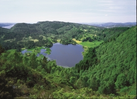
Herlandsnesjane, a four-kilometre long peninsula in Lake Storavatnet in the middle of Osterøy, is well known among botanists. Here lies an unusually large and diverse bog.

Mjøsvågen
Around Mjøsvågen here is still a compact marine use area. Some of the buildings are common boathouses, but most of them also house small enterprises and workshops. This is where the farmers from Øvsthus, Mjøs, Hole and other farms have supplemented their meagre incomes as smiths, brass moulders, clog makers, chest builders and decorative painters.

Fitjarøyane
If we study the group of islands south of Selbjørns Fjord from the air or on a sea map, we will notice that many of the islands are elongated and lie systematically in rows. The islands are divided by long sounds, for example Trollosen, Nuleia and Hjelmosen, which are oriented in a south-southeast to north-northwesterly direction.

Grønafjellet
Mountain plants with their beautiful, colourful flowers are common in high altitude areas in Norway. On the coast there are not so many of them. But, here and there one nonetheless finds mountain plants, and this makes some coastal mountainsides a little bit different. Perhaps the growth on these mountainsides gives us a little glimpse of a distant past?

