- Remove Small landforms filter Small landforms
- Remove Large landforms filter Large landforms
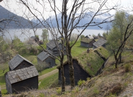
- Remove Hardanger og Voss filter Hardanger og Voss
- Remove Museum filter Museum
- Remove Middle age filter Middle age
- Remove Maritime environments filter Maritime environments
- Remove People and Society filter People and Society
- Remove Defense filter Defense
- Remove Place filter Place
- Remove Churches filter Churches
- Remove Museums, nature conservation, cultural heritage filter Museums, nature conservation, cultural heritage
- Remove Landscape filter Landscape
- Remove Chieftains and royal lines filter Chieftains and royal lines


Måbødalen- geology
The old pack road had 1500 steps, where cars today gas through the mountain. The time of this hard work is over, and of getting used to the steep terrain, as well; only the view from the top is much the same as before. Vøringsfossen in summer is one of Western Norway’s biggest natural wonders. It marks the transition between the older, open part of the Sysendalen valley and the younger, narrow and winding valley of Måbødalen.

Hårteigen
Hårteigen, «the grey signpost», as the name suggests, is a landmark for mountain hikers on the western plateau. The piece of mountain is also a monument for the mighty rock layers that once covered the entire plateau.

Tokagjelet
There is a sharp transition between the wide valley at Kvamskogen and the narrow Tokagjelet. The transition is no less dramatic when we come out of the crooked tunnels far down in the canyon, and the open Steinsdalen valley spreads out before us. The canyon both separates and joins together different epochs in western Norway's history.

Skjervet- river theft
At the end of the last ice age the ice flowed out of Hardanger fjord in such a fury that it forced the meltwater from Voss to run back uphill toward Granvin. The glacier from Raundalen down the windy valley along the Vosso to Bolstadøyri went too slow to make the turn.

Jomfrunuten
Freezing and thawing are processes that influence plant cover, move enormous blocks, stretche long mounds of earth, break open bedrock and create patterns in stone and earth.