- Remove Small landforms filter Small landforms
- Remove Austevoll filter Austevoll
- Remove Large landforms filter Large landforms
- Remove Maritime environments filter Maritime environments
- Remove Seabirds filter Seabirds
- Remove Monastery filter Monastery
- Remove Sund, frå 2020 del av nye Øygarden kommune filter Sund, frå 2020 del av nye Øygarden kommune
- Remove Fitjar filter Fitjar
- Remove Osterøy filter Osterøy
- Remove Chieftains and royal lines filter Chieftains and royal lines
- Remove Bergen filter Bergen
- Remove Øygarden, frå 2020 del av nye Øygarden kommune. filter Øygarden, frå 2020 del av nye Øygarden kommune.

Mjøsvågen
Around Mjøsvågen here is still a compact marine use area. Some of the buildings are common boathouses, but most of them also house small enterprises and workshops. This is where the farmers from Øvsthus, Mjøs, Hole and other farms have supplemented their meagre incomes as smiths, brass moulders, clog makers, chest builders and decorative painters.


Goltasundet
For generations the land-seine was the most important tool for catching herring and mackerel, and therefore a suitable casting bay was worth its weight in gold. Goltasundet (the Golta sound) on Golta was such a place. Here the herring often drifted in and fantastic casts might be made here.


Skogsøyna
There isn't much forest on Skogsøyna today, but that there is, has been planted. There is not much wildlife, either. But, quite a lot of birds pass by Skogsøyna during migration time. Ther is no other place along the coast where you can better observe the seabird migrations.
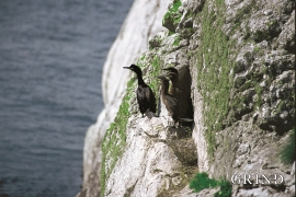
Møkster- seabirds
Fish and guests smell after three days, it is said. The cormorants do not need this long. If you follow your nose, the cormorant is not difficult to find.


Fitjarøyane
If we study the group of islands south of Selbjørns Fjord from the air or on a sea map, we will notice that many of the islands are elongated and lie systematically in rows. The islands are divided by long sounds, for example Trollosen, Nuleia and Hjelmosen, which are oriented in a south-southeast to north-northwesterly direction.

