- Remove Small landforms filter Small landforms
- Remove Austevoll filter Austevoll
- Remove Large landforms filter Large landforms
- Remove Maritime environments filter Maritime environments
- Remove Seabirds filter Seabirds
- Remove Monastery filter Monastery
- Remove Fitjar filter Fitjar
- Remove Avalanches and rock falls filter Avalanches and rock falls
- Remove Etne filter Etne
- Remove Vernacular crafts filter Vernacular crafts
- Remove Farming and forestry filter Farming and forestry
- Remove Kvinnherad filter Kvinnherad
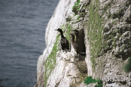
Møkster- seabirds
Fish and guests smell after three days, it is said. The cormorants do not need this long. If you follow your nose, the cormorant is not difficult to find.


Fitjar- potatoes
The deep agricultural soils in Fitjar are found especially in the area between Lake Storavatnet and Breivika. The many stonewalls in the area reflect that the earth probably was full of stones and stone blocks. The stones that couldn't be dug out had also a function: they stored heat that helped to grow potatoes.

Fitjarøyane
If we study the group of islands south of Selbjørns Fjord from the air or on a sea map, we will notice that many of the islands are elongated and lie systematically in rows. The islands are divided by long sounds, for example Trollosen, Nuleia and Hjelmosen, which are oriented in a south-southeast to north-northwesterly direction.

Skorpo
Skorpo - Polished by glaciers and meltwater

Ulvanosa
Some mountains have rounded shapes, while others have steep slopes and sharp edges. Ulvanosa (1246 mos.) has both. The forms reflect the type of bedrock below, and the forces that were in effect when they were formed.

Melderskin
MELDERSKIN - ONCE A NUNATAK? Melderskin, the towering and majestic landmark at Rosendal, rises 1462 metres above sea level. The top area is smooth, but slightly inclined. Geologists think that the area is a remnant of a weakly undulating landscape, that originated near the sea, long before the Ice Age set in.

