- Remove Small landforms filter Small landforms
- Remove Radøy, frå 2020 del av nye Alver kommune. filter Radøy, frå 2020 del av nye Alver kommune.
- Remove Conservation area filter Conservation area
- Remove Maritime environments filter Maritime environments
- Remove Seabirds filter Seabirds
- Remove Monastery filter Monastery
- Remove Fitjar filter Fitjar
- Remove Avalanches and rock falls filter Avalanches and rock falls
- Remove Etne filter Etne
- Remove Igneous rocks filter Igneous rocks
- Remove Fedje filter Fedje
- Remove Modalen filter Modalen


Nedre Helland- skred
Many still remember when the avalanche struck Nedre Helland, on the 14th of August, 1953 14:30 o'clock. All of the buildings at one of the farms and the main house on the neighbouring farm were destroyed. The one woman who was inside a building escaped, frightened but unharmed. The same with the others who lived at Nedre Helland; everyone was a safe distance from the avalanche.

Otterstadstølen
Otterstadstølen lies in an idyllic grassy plain surrounded by rich forest, but also with high mountains close by. The mountainsides are steep and typical of this part of the county. The same cannot be said about the forest. This spruce forest has been able to develop freely for hundreds of years. Otherwise in the county, only Voss has spruce forest.

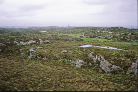
Fedje bog
The wild rabbit is really native to Northwest Africa, but the Ancient Romans introduced them to large parts of Europe. Not to Norway, rightly enough: the population on Fedje originated from 3-4 pairs that were brought here from the Shetland Isles in 1875, making this their first residence in the country.

Manger
Mangerite is a rock type that was first made famous in a treatise by the Bergen geologist Carl Fredrik Kolderup in 1903. The rock type got its name from the place where it was found, and has made the Mangerud name well known around the world, at least among geologists.


Rimbareid- Vestbøstad
At nesting time you cannot avoid hearing the calls of the curlew or the snipe along the narrow road through the cultural landscape from Rimbareid to Vestbøstad. And on late summer evenings, the intense song of the sedge warbler rings out over the two characteristic tarns in the area.

Fitjarøyane
If we study the group of islands south of Selbjørns Fjord from the air or on a sea map, we will notice that many of the islands are elongated and lie systematically in rows. The islands are divided by long sounds, for example Trollosen, Nuleia and Hjelmosen, which are oriented in a south-southeast to north-northwesterly direction.

