- Remove Small landforms filter Small landforms
- Remove Tysnes filter Tysnes
- Remove Igneous rocks filter Igneous rocks
- Remove Odda, frå 2020 del av nye Ullensvang kommune. filter Odda, frå 2020 del av nye Ullensvang kommune.
- Remove Maritime environments filter Maritime environments
- Remove Seabirds filter Seabirds
- Remove Monastery filter Monastery
- Remove Fitjar filter Fitjar
- Remove Ullensvang, frå 2020 del av nye Ullensvang kommune. filter Ullensvang, frå 2020 del av nye Ullensvang kommune.
- Remove Etne filter Etne
- Remove Rock carvings filter Rock carvings
- Remove Avalanches and rock falls filter Avalanches and rock falls
- Remove Tourism filter Tourism

Buardalen Valley
Buarbreen glacier was one of the first destinations during the period of increasing tourism in Odda in the 1800s. Foreigners came by the thousands, mostly Englishmen and Germans, to the magnificent landscape in front of the glacier. Back at the hotel in Odda they could enjoy drinks containing ice from the glacier.

Kalvanes
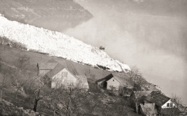
On the 17th of January, 1993, the area between the towns of Odda and Eitrheimsneset were struck by a giant avalanche. One person was killed, and there was a lot of material damage.


Fluøyane
The richest seabird localities in Bjørna Fjord are FLUØYANE, a group of small and medium-sized islets just east of the entrance to Våge. Here, we see many different nesting birds, but there is the danger that overgrowth will become an obstacle for nesting here in the future. On one of the islands, the environmental protection authority has promised to step in and help the birds.

Espevik
220 million years ago, glowing hot molten rock masses intruded into fractures in the earth's crust in the outer parts of Hordaland. Some of these are believed to have reached the surface and formed lava flows, which since have been eroded away by wind and weather. But, most of these flows solidified into diabase sills before they got to the surface.


Fitjarøyane
If we study the group of islands south of Selbjørns Fjord from the air or on a sea map, we will notice that many of the islands are elongated and lie systematically in rows. The islands are divided by long sounds, for example Trollosen, Nuleia and Hjelmosen, which are oriented in a south-southeast to north-northwesterly direction.

