- Remove Small landforms filter Small landforms
- Remove Vaksdal filter Vaksdal
- Remove Maritime environments filter Maritime environments
- Remove Seabirds filter Seabirds
- Remove Monastery filter Monastery
- Remove Sund, frå 2020 del av nye Øygarden kommune filter Sund, frå 2020 del av nye Øygarden kommune
- Remove Fitjar filter Fitjar
- Remove Osterøy filter Osterøy
- Remove Mineral resources filter Mineral resources
- Remove Trading posts and guesthouses filter Trading posts and guesthouses
- Remove Iron age filter Iron age
Bukken
In Christian IV’s diary from Norgesreisa (trip to Norway) in 1599, we find the reference or anecdote that is the origin of the name Bukken. A Dutch full-rigged ship once passed the mountain outcrops on the island with the guesthouse so close that a ram grazing there jumped down on a yardarm (rånokk), thus the name “Buch van Raa!”

Dale farm
The Dale farm lies well situated on the gravel by the river, below the mountain Beitelen. But a few stone throws further north, on the wide expanse behind the houses, there has been an older farmstead. Here there have been found a number of cooking hollows, pole holes, an old road and traces of something believed to have been a palisade. Finds from this oldest farmstead may be dated to the time of the migrations, 400-600 years A.D.

Engesund
For more than 350 years Engesund has been a place for hostelries and trading in the Fitjar islands. The place is centrally placed in the shipping lane, with a sheltered harbour close to the exposed Selbjørnsfjorden. Engesund was once part of the great network of historical stopover places on the coast.

Fitjar- the King's farm
In front of Fitjar Church there is a memorial stone, sculpted by Anne Grimdalen and erected in 1961, for the thousand-year memorial of one of the most dramatic events in Norway’s history, the Battle of Fitjar. This was the place where Norway’s king, Håkon the Good, suffered his fatal injury in the fight with Eirik’s sons, probably in the year 961.

Færøysund
The old trading post lies at the sound between Stord and Færøy in Langenuen. There was a country store and steamship forwarding agent up to 1964. The trade was then moved over to the new ferry harbour of Sandvikvåg.
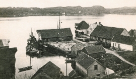
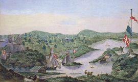
Glesvær- Trading post
Glesvær is one of the oldest trading posts on the West Norwegian coast. In the 1700s and 1800s this was the most important fishing centre on Sotra. The first certain mention of the trading station Glesvær is in 1664. At that time it was the Bergen merchant Hendrich Wessel who owned the place and was in the possession of a trading privilege. Abraham Wessel, who took over in 1688 also obtained Royal Privilege for “Kiøbmandskab med Bønderne alleene at drive” (the only one to be allowed to carry on trade with the farmers).

Golta- Long house
In the years between the wars a major registration of houses and house costumes, house construction methods, fireplaces and forms of housing clusters was started in West Norway – an ambitious mapping of everything that came under the name “Registration of Culture and Geography in West Norway”. One of the places of which material was gathered in 1938 was an old multi-room house at Golta; new and interesting material for the researchers from the Historical Museum, but well known within the local building tradition through several generations.

Goltasundet
For generations the land-seine was the most important tool for catching herring and mackerel, and therefore a suitable casting bay was worth its weight in gold. Goltasundet (the Golta sound) on Golta was such a place. Here the herring often drifted in and fantastic casts might be made here.

Grønafjellet
Mountain plants with their beautiful, colourful flowers are common in high altitude areas in Norway. On the coast there are not so many of them. But, here and there one nonetheless finds mountain plants, and this makes some coastal mountainsides a little bit different. Perhaps the growth on these mountainsides gives us a little glimpse of a distant past?


