- Remove Modalen filter Modalen
- Remove Maritime environments filter Maritime environments
- Remove Austrheim filter Austrheim
- Remove Fitjar filter Fitjar
- Remove Fish filter Fish
- Remove Vernacular crafts filter Vernacular crafts
- Remove Bronze age filter Bronze age
- Remove Voss, frå 2020 del av nye Voss herad. filter Voss, frå 2020 del av nye Voss herad.

Krossøy
Furthest north in the island community Rongevær, at the entrance to Fensfjorden, lies Krossøy. Belonging to the farm are the islands of Krossøy, Husøy, Kårøy, Lyngkjerringa, Søre Kjerringa, Rotøy and Kuhovet. All of them have been inhabited. On Krossøy itself today there are four holdings. The marine use environment here is one of the best preserved along the West Norwegian coast.

Otterstad
Tthe Otterstad farms lie in the innermost part of Mofjorden, on the northwest side of the river. The row of stave-built boatsheds that belong to the farm were probably constructed a little after the middle of the 1800s. Both here and on the Mo side, the boatsheds were important storage places at the seashore; wood and other farm products intended for the town; corn and merchandise in return.


Rimsvarden
Rimsvarden lies high and unencumbered, an enormous stone mound on the highest top with a wide view of the Fitjar rural community. With its 30 meters across and almost 4 meters high, this is one of the largest prehistoric burial relics existing in Hordaland.


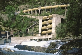
Evanger
Evanger (from Old Norse ålvangr, “vang”, “voll” (field) where the horses may graze) is the place where the river from Vangsvatnet, the Voss watercourse, runs out into Evangervatnet. From here Teigdalen valley runs to the north, towards Eksingedalen, and from here there is a short distance to Bergsdalen in the south.


