- Remove Modalen filter Modalen
- Remove Trading posts and guesthouses filter Trading posts and guesthouses
- Remove Maritime environments filter Maritime environments
- Remove Austrheim filter Austrheim
- Remove Factories filter Factories
- Remove Stone age filter Stone age
- Remove Sund, frå 2020 del av nye Øygarden kommune filter Sund, frå 2020 del av nye Øygarden kommune
- Remove Bergen filter Bergen
- Remove Sedimentary rocks filter Sedimentary rocks
- Remove Basement rocks filter Basement rocks
- Remove Radøy, frå 2020 del av nye Alver kommune. filter Radøy, frå 2020 del av nye Alver kommune.


Goltasundet
For generations the land-seine was the most important tool for catching herring and mackerel, and therefore a suitable casting bay was worth its weight in gold. Goltasundet (the Golta sound) on Golta was such a place. Here the herring often drifted in and fantastic casts might be made here.


Golta- Gneiss
Over thousands of years, autumn storms and strong land-driving winds have cleaned the bare rocks of Golta. The waves can beat far in over land and make it dangerous to walk along the shoreline. When the storms have calmed, the results of their work comes into view.

Sandviksfjellet
On Sandviksfjellet there are old boulders that have been made into mountains. The stones have been stretched out or squeezed together between huge slabs of rock, during slow, but powerfulprocesses of transport. This conglomerate shows, in quite a special way, the enormous powers that were active during the collision between Norway and Greenland over 400 million years ago.

Otterstad
Tthe Otterstad farms lie in the innermost part of Mofjorden, on the northwest side of the river. The row of stave-built boatsheds that belong to the farm were probably constructed a little after the middle of the 1800s. Both here and on the Mo side, the boatsheds were important storage places at the seashore; wood and other farm products intended for the town; corn and merchandise in return.

Krossøy
Furthest north in the island community Rongevær, at the entrance to Fensfjorden, lies Krossøy. Belonging to the farm are the islands of Krossøy, Husøy, Kårøy, Lyngkjerringa, Søre Kjerringa, Rotøy and Kuhovet. All of them have been inhabited. On Krossøy itself today there are four holdings. The marine use environment here is one of the best preserved along the West Norwegian coast.
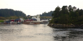
Kjelstraumen
If you take the sea route north you have several options. The various routes have been dealt with in history, and through the Middle Ages the traffic increased as well as the trading with Nordland in fish and herring, feather and down. One of the central routes passes through Kjelstraumen, in the sound between Ulvøy and Bakkøy. This has been a place for a guesthouse since 1610, with Royal Letter of Privilege, part of the large network of trading post and guesthouse locations along the coast.

Hopland
The farmhouses at holding No. 15 at Hopland are built together to form a long, continuous building, with dwelling house, hayshed and cowshed built in one row. There have been many such joined structures in the coastal communities, but today there are few remaining. If we travel to the other side of the North Sea, to the Faeroes, Shetland and the Orkney Islands, we find corresponding features in the older building traditions. We find ourselves in a large North Atlantic cultural area.

Fosnstraumen
At the southern end of the bridge between Radøy and Fosnøy archaeologists found an unusual Stone Age settlement. There was a thick “cultural layer” here with the remains of the waste dumps of a hunting people. The place was called Kotedalen. Here they came, one group after the other, and settled for some weeks, some months, or maybe years before they went on, leaving the settlement deserted. Time after time it happened. At least 16 settlement phases have been identified, stretching over 5,500 years.

