- Remove Modalen filter Modalen
- Remove Factories filter Factories
- Remove Maritime environments filter Maritime environments
- Remove Austrheim filter Austrheim
- Remove Nordhordland filter Nordhordland
- Remove Place filter Place
- Remove Vaksdal filter Vaksdal
- Remove Civil servant dwellings and manors filter Civil servant dwellings and manors
- Remove Fish filter Fish
- Remove Late glacial filter Late glacial
- Remove Quarns and mills filter Quarns and mills


Krossøy
Furthest north in the island community Rongevær, at the entrance to Fensfjorden, lies Krossøy. Belonging to the farm are the islands of Krossøy, Husøy, Kårøy, Lyngkjerringa, Søre Kjerringa, Rotøy and Kuhovet. All of them have been inhabited. On Krossøy itself today there are four holdings. The marine use environment here is one of the best preserved along the West Norwegian coast.


Mostraumen
Until 1743 the people from Modal had to wait for a flood in MOSTRAUMEN before they could draw their boats up the river current, and then row back across Lake Movatnet. But, that year the flood opened a free passageway all the way to Mo. Hordaland had gained a new tidal waterway.

Nedre Helland- Sand Quarries
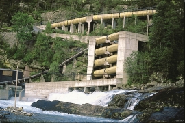
The three spades in the municipal coat of arms for Modalen are sand spades. Sand quarrying has brought income and employment. As much as 70,000-80,0000 tonnes of sand and gravel left the municipality each year since the turn of the millennium, to be used as cementing sand. Why is Modalen endowed with so much sand?

Otterstad
Tthe Otterstad farms lie in the innermost part of Mofjorden, on the northwest side of the river. The row of stave-built boatsheds that belong to the farm were probably constructed a little after the middle of the 1800s. Both here and on the Mo side, the boatsheds were important storage places at the seashore; wood and other farm products intended for the town; corn and merchandise in return.


Eksingedalen- landscape
Eksingedalen alternates between wide, flat flood plains with good farmland, and narrow passages with waterfalls where the roads cling to the mountainsides. The alternations in the landscape are a result of the sculpturing work by glaciers over several ice ages, and the deposition of the glacial river deposits when the last glacier finally melted back.


