- Remove Bedrock filter Bedrock
- Remove Wildlife filter Wildlife
- Remove Lindås, frå 2020 del av nye Alver kommune. filter Lindås, frå 2020 del av nye Alver kommune.
- Remove Granvin, frå 2020 del av nye Voss herad filter Granvin, frå 2020 del av nye Voss herad

Granvinsvassdraget
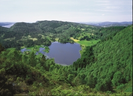
After the ice age, Granvin Fjord reached all the way up under Skjervsfjossen waterfall. Just a thousand years later, as a result of the rising of the land after the ice melted, this whole inner part of the fjord freed itself of the sea and became Granvinsvatnet lake. In spite of this rise in elevation, this waterway is still navigable for fish: Sea trout have wandered into Granvinsvatnet in more recent times and evolved to become freshwater trout. And salmon and sea trout made the journey 13 kilometres up the Storelvi river.

Lussand- geology
Hardangerfjorden kløyver Hordaland i to. Den etter måten rettlinja fjorden skjer seg liksom på skeive inn i landet. Ikkje som Sognefjorden og Nordfjord – dei krokar og buktar seg innover meir eller mindre vinkelrett på kysten. Hardangerfjordens utforming har røter 400 millionar år tilbake i tida, då den veike sona i fjellet, der isen seinare tok grådig for seg, vart danna. Denne sona stig på land ved Lussand.

Fossevatna
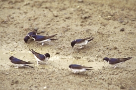
Fossevatna, some few kilometres north of Alversund, is one of the finest wetland areas in Lindås. Especially the birdlife has made this place well known. Throughout the year, one can make exciting bird discoveries. But, if you want to hear the flight games skal høre med fagredaktør Stein Byrkjeland of the Snipe, you should come here on a spring or summer evening.
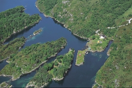
Lure Fjord
Both Lure Fjord and Lindåsosane to the inside give good living conditions for rare marine organisms: jellyfish, shellfish and fish. These include animals that migrated in after last the Ice Age, when the sea level was higher. Eventually, as the land rose, some of these populations became isolated.


Stall
The Bergen Arcs have an unusually sharp boundary to the bedrock in the east. Geologists think that this was caused by movements in the earth's crust during the Devonian Period. Then, the Bergen Arcs on the Lindås peninsula sank a whole 10 kilometres in relation to the Precambrian basement gneisses on the east side of Fens Fjord and Aust Fjord.

