- Remove Museums, nature conservation, cultural heritage filter Museums, nature conservation, cultural heritage
- Remove Arkeologi filter Arkeologi
- Remove Museum filter Museum
- Remove Midthordland filter Midthordland
- Remove Settlements, Villages, Towns filter Settlements, Villages, Towns
- Remove Farm sites filter Farm sites
- Remove Sunnhordland filter Sunnhordland
- Remove Mountain farms filter Mountain farms
- Remove Nordhordland filter Nordhordland


Arnatveit
On the farm of Arnatveit, high up on the slope above the highway, an old smokehouse remains standing in the courtyard of the main farm property, in the place of the old common courtyard. Today this farm lies at the outskirts of a large housing estate. Most of the farmland of the other farm properties has been sold to benefit the city’s need of sites for the new community of Arna.

Boga
In the lightly undulating landscape at Boga there lies an old house with several rooms on a small rise. In fact it looks like three houses built into one another; a scullery, a living room and a store with a loft. From other sources we know that this house had covered passageways and sheds round all the walls in the 19th century; a compressed “long house” with inter-connections between all the rooms. This is a building style from the Middle Ages that we see traces of; a building corresponding to those we have seen remains of at Høybøen in Fjell and Lurekalven in Lindås. Bogatunet was restored in 2006.

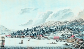
Bryggen
In the 1300s Bergen was a trading centre of European dimension. The town is thought to have had around 7000 inhabitants and was the largest and most important in the country. In a European context it was an average size town. At this time the most tightly built town area was still mostly east of Vågen from Holmen in the north to Vågsbotn in the south. Already in medieval times, latest in the 1340s, this area was called Bryggen.
Damsgård
As a fairytale castle Damsgård Hovedgård lies on the slope rising up from the Puddefjord. The old connection between the farm and the sea, as we see it on Dreier’s prospectus from 1810, has been broken up by roads and encroachments in the building mass. But the main building itself is a central monument in Norwegian architecture from the 1700s – one of the finest representatives for the rococo period, with a magnificent and rich décor both in its interior and exterior.

Einstapevoll- the farm
Einstapevoll (from einstape: “bregne” (fern)) lies on the west side of the Tittelsnes peninsula. Up to 1831 the farm was a vicarage belonging to Stord parish. The priests had leasing rights. Land rent and other fees from the farm was part of their salaries.

Færavåg
The main house at Færavåg was built in 1599. History tells us that a German came to Færavåg and built the house. He divided the land between his two sons. They in turn divided it between their two sons, thus there were four equal holdings on the farm. And it is said that all households lived in the same house. They each stayed in their own corner around the fire in the middle of the floor.


Golta- Long house
In the years between the wars a major registration of houses and house costumes, house construction methods, fireplaces and forms of housing clusters was started in West Norway – an ambitious mapping of everything that came under the name “Registration of Culture and Geography in West Norway”. One of the places of which material was gathered in 1938 was an old multi-room house at Golta; new and interesting material for the researchers from the Historical Museum, but well known within the local building tradition through several generations.

Gullbrå
From written sources we know that the farm Gullbrå was in use early in the 1600s. The Apostolic church in Bergen owned land here that it rented out, but even early in the 1600s some of the land was in private ownership. Eksingedalen then belonged to Modalen parish, which was under Hamre parish. In 1723 the Apostolic church still had properties here, and Ivar and Lars were farmers.

