- Remove Middle age filter Middle age
- Remove Road constructions filter Road constructions
- Remove Nordhordland filter Nordhordland
- Remove Place filter Place
- Remove Vernacular crafts filter Vernacular crafts
- Remove Sunnhordland filter Sunnhordland
- Remove Metamorphic rocks filter Metamorphic rocks
- Remove Rock carvings filter Rock carvings

Salhusfjorden
When the debate about building a pontoon bridge over Salhus Fjord was raging, some were afraid that the bridge would disrupt the ecology of the fjord system inside. The worst predictions did not prove true, but it is easy to see that there was a change: the Puffins have gotten a new food platter after the Nordhordaland bridge was built. Its favourite meal, mussels, thrive on the pontoons that are the foundation for the bridge.

Helgaberget
Helgaberget – the holy hill – is a little rocky crag which thrusts itself a few metres above the terraced surface of Støle. The surface of the rock is strewn with figures inscribed in the rock and it was, as far as one can judge, a cult centre in the Bronze Ages. The name could indicate that the tradition of holiness can have lasted for almost 3,000 years.

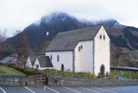
Støle church
The stone church at Støle may have been built around 1160 probably as a private chapel for the mighty Stødle clan. It is likely that it was Erling Skakke, the king’s representative and father of king Magnus Erlingsson, who built the church.

Halsnøy Monastery
Halsnøy Monastery is situated in the midst of the lush fjord country in Sunnhordland, on one of the old spits, or “necks”, that has given name to the island. Gently sloping fields lead down to the sea on both sides, in the south towards the Kloster Fjord, to the north towards the sheltered Klostervågen.
Kvinnherad Church
The stately Kvinnherad Church with its characteristic profile set out against the mighty Malmangernuten in the background, gives you a rare feeling of being present in a historic landscape as you come around Nes and face the well-kept houses at the Skåla farm. The church at Skåla is one of four “fjordungskirker” (one of four main district churches) and this farm was the centre of this coastal administration district.

Årsand
Below a south facing, steep rock at Årsand, there is one of the strangest ancient relics in the whole of Hordaland. The jutting rock wall forms a shallow flagstone – Geithilderen. Parts of the rock wall are covered by a light lime crust and on the crust figures have been painted in golden and rusty red colours.

Moster- The old church
Moster is mentioned as a church site already in the time of Olav Tryggvason. According to the sagas the king is supposed to have laid the foundations for the first church at Moster when he came there in 995. That building would have been a stave church - the church standing there today – a stone church with a nave and narrower, straight chancel – was probably founded around 1100. In 1874 a new church was built at Moster. Then the old church was bought by The Society for the Preservation of Norwegian Ancient Monuments, which is still the owner.

Odland
The auger smithies in Odland and Fosse were amongst those which had the largest production of augers in the period between the Wars. Martinus Fosse built a smithy in 1877, and this was in operation right up to the 1980s - one of the centres for auger production in Meland. In 1930 yet another smithy was built here. There was a smithy at Fossesjøen as early at the 18th century, and at the end of the 19th century they went over to auger smithing. There is still a market for hand-forged augers.

Kolåseidet
The little cowshed which lies on the fence at Kolåseidet, constructed in connection with the stone fence, has put its mark on the cultural landscape. On the border between the home fields and the forest, the cowshed is the very symbol of a simple resource management - the division between the cropland and the grazing grounds. And the way it was built has its roots far back in time.

Matrehola
On a large gravel terrace in Matredalen (the Matre valley), a couple of kilometres from the coastal settlement Matre, lies Storseterhilleren, at the end of a large stone block that came rushing down from the mountain. The Matre river runs just over 100 metres to the east of the cave.

