- Remove Modalen filter Modalen
- Remove Settlements, Villages, Towns filter Settlements, Villages, Towns
- Remove Radøy, frå 2020 del av nye Alver kommune. filter Radøy, frå 2020 del av nye Alver kommune.
- Remove Fedje filter Fedje
- Remove Churches, Cloisters, Christianity filter Churches, Cloisters, Christianity

Mo
The farms in Modalen are situated on old, fertile sediment beds from the river or the sea – between Mofjorden and Steinslandvatnet. As far back as the Middle Ages Mo has been a church location for the valley and the farms above.


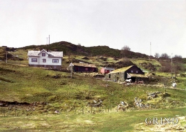
Nottveit
In one of the frame-built haysheds at Nottveit, at holding No. 3, we discover that several of the staves have a medieval look, with large dimensions and carefully rounded edges. According to tradition, it was the farms Nottveit and Mostraumen that supplied the timber for the stave church at Mo, and it is not unlikely that these farms received the old timber in return when the new church was erected there in 1593.

Otterstad
Tthe Otterstad farms lie in the innermost part of Mofjorden, on the northwest side of the river. The row of stave-built boatsheds that belong to the farm were probably constructed a little after the middle of the 1800s. Both here and on the Mo side, the boatsheds were important storage places at the seashore; wood and other farm products intended for the town; corn and merchandise in return.

Hellisøy
Hellisøy lighthouse was lit for the first time in 1855. The characteristic red cast-iron tower with two white belts is 33m high and a light height of 46m above high tide.

Kræmmerholmen
Kræmmerholmen is one of the old privileged trading posts. From the 1600s all trading in West Norway took place in Bergen, and the farmers were obliged to travel into town in order to sell their produce and buy what they needed. In Bergen City Privilege of 1702 the merchants in the city were allowed to establish “Trading posts in the countryside”. The owner had to have residency in Bergen and the trading post was to be run by an assistant. In this way the city retained financial control of those living in the districts, and not least with buying and selling of fish.
Øvre Tveiten
On an east-facing slope above Halllandsvatnet lies the farm hamlet of Øvre Tveiten, two kilometres north of Manger. The stone hayshed lies with its gable out into the sloping terrain, and the old dwelling house, a little long house, has solid stone walls on three sides. But inside the walls the hayshed and the living rooms are wooden buildings.

Boga
In the lightly undulating landscape at Boga there lies an old house with several rooms on a small rise. In fact it looks like three houses built into one another; a scullery, a living room and a store with a loft. From other sources we know that this house had covered passageways and sheds round all the walls in the 19th century; a compressed “long house” with inter-connections between all the rooms. This is a building style from the Middle Ages that we see traces of; a building corresponding to those we have seen remains of at Høybøen in Fjell and Lurekalven in Lindås. Bogatunet was restored in 2006.

Kolåseidet
The little cowshed which lies on the fence at Kolåseidet, constructed in connection with the stone fence, has put its mark on the cultural landscape. On the border between the home fields and the forest, the cowshed is the very symbol of a simple resource management - the division between the cropland and the grazing grounds. And the way it was built has its roots far back in time.

