- Remove Boat- and shipyards filter Boat- and shipyards
- Remove Cultural landscapes filter Cultural landscapes
- Remove Large landforms filter Large landforms
- Remove Sunnhordland filter Sunnhordland
- Remove Trading posts and guesthouses filter Trading posts and guesthouses


Bondhusdalen
The Bondhus area in Maruanger has been a magnet for tourists ever since the stream of tourists to Norway's west coast began in the middle of the 1800s. The magnificent landscape with the "ice trail" up to Bondhusvatnet Lake, the ice falls from Bondhusbreen glacier and Keisarstigen trail up to Folgefonna are still popular tourist attractions.

Brandasund
On Gisøya Island, on the west side of Brandasund Sound, there is a very privileged trading post and traveller's Inn from the 1600s, with the North Sea as its nearest neighbour. In 1991 a road was built over Bømlo out to these islands, but for thousands of years the sheltered harbour here was a main stopping place along the outer coast. During the great herring period of the 1700s and 1800s, Brandasund was a centre for the herring fisheries on the Sørafeltet fishing grounds. Today, the area belongs to the municipality of Bømlo.

Engesund
For more than 350 years Engesund has been a place for hostelries and trading in the Fitjar islands. The place is centrally placed in the shipping lane, with a sheltered harbour close to the exposed Selbjørnsfjorden. Engesund was once part of the great network of historical stopover places on the coast.

Espevær- the Trading Post
In the sea west of Bømlo lies Espevær, half an hour’s rowing trip across the sound from Vespestadvågen. This is a well-run and well-maintained local community, established on the back of the rich herring fisheries in the 1850s. It is fishermen, skippers and the tradesmen who have made their mark on the culture in Espevær, with their contacts to the south towards Haugesund and across the North Sea to the British Isles.

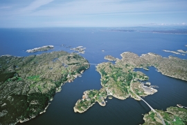
Fitjarøyane
If we study the group of islands south of Selbjørns Fjord from the air or on a sea map, we will notice that many of the islands are elongated and lie systematically in rows. The islands are divided by long sounds, for example Trollosen, Nuleia and Hjelmosen, which are oriented in a south-southeast to north-northwesterly direction.

Færøysund
The old trading post lies at the sound between Stord and Færøy in Langenuen. There was a country store and steamship forwarding agent up to 1964. The trade was then moved over to the new ferry harbour of Sandvikvåg.


Godøysund
The old hostelry centres were strategically placed with good harbours and anchoring conditions where people travelled. GODØYSUND, or Gøysundet, as it was called, was in the middle of Tysnes Parish, with easy access from the sea, also for the local population. Gøysundet is amongst the oldest hostelries in Sunnhordland.

