- Remove Small landforms filter Small landforms
- Remove Maritime environments filter Maritime environments
- Remove Seabirds filter Seabirds
- Remove Monastery filter Monastery
- Remove Sund, frå 2020 del av nye Øygarden kommune filter Sund, frå 2020 del av nye Øygarden kommune
- Remove Fitjar filter Fitjar
- Remove Sediments filter Sediments
- Remove Farm sites filter Farm sites
- Remove Etne filter Etne

Golta- Long house
In the years between the wars a major registration of houses and house costumes, house construction methods, fireplaces and forms of housing clusters was started in West Norway – an ambitious mapping of everything that came under the name “Registration of Culture and Geography in West Norway”. One of the places of which material was gathered in 1938 was an old multi-room house at Golta; new and interesting material for the researchers from the Historical Museum, but well known within the local building tradition through several generations.

Årskog
Årskog farm is situated in a typical coastal landscape in a gentle terrain that slopes down from the outlying heaths down towards the fjord. The farm steading exists as it was in the 1800s. In 1980 the two brothers, Lars and Olai Årskog donated the farm with all its contents of tools and interior decoration, for museum purposes.
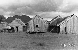
Sæbøtunet
When you come into the well-tended farm steading at Sæbø just above Etne centre, you get the impression of a Sunnhordland farm from well before the time of the tractor; from the time of the horse and the scythe. The hamlet at Sæbø, one of the farms neighbouring to Gjerde, was taken over by Sunnhordland Folk Museum in 1938.

Goltasundet
For generations the land-seine was the most important tool for catching herring and mackerel, and therefore a suitable casting bay was worth its weight in gold. Goltasundet (the Golta sound) on Golta was such a place. Here the herring often drifted in and fantastic casts might be made here.


The village of Etne
Much of the sand and gravel that the town of Etne is built on was laid down at the end of the Ice Age and is evidence of melting glaciers and roaring meltwater rivers. The uncompacted material in the big terraces leave their unmistakeable mark on the wide elongated valleys.

Fitjar- potatoes
The deep agricultural soils in Fitjar are found especially in the area between Lake Storavatnet and Breivika. The many stonewalls in the area reflect that the earth probably was full of stones and stone blocks. The stones that couldn't be dug out had also a function: they stored heat that helped to grow potatoes.


Skånevik- moraine
In Skånevik there are marks left from the ice edge that advanced during the thousand-year cold spell (Younger Dryas) that marked the end of the Ice Age roughly 11 500 years ago. The glacier first proceeded out into Åkra Fjordand and around Vannes and thereafter sent an arm in toward Skånevik. Here, the glacier lay down an end moraine up against the mountainside.

