- Remove Boats and seafaring filter Boats and seafaring
- Remove Vernacular crafts filter Vernacular crafts
- Remove Farm sites filter Farm sites
- Remove Plants by the sea filter Plants by the sea
- Remove Conservation area filter Conservation area

Haugsbø
The single unit farm without a road to it, Haugsbø, is situated on the east side of the Tittelsnes peninsula facing Ålfjorden. As far back as the Middle Ages the farm has probably belonged to Stord Parish, up to the 1800s. In 1590 it was thought to be abandoned, but in 1601 Mickel Hougsbøe paid a tithe on the farm.

Hopsfjellet
On June 2nd, 1992, a big forest fire broke out in Sveio. The fire started southeast of Hopsfjellet. In a strong wind the flames spread quickly northward. Houses on the other side of the highway were threatened, but escaped unscathed. The burned area, which is easily visible about a 5 minute's drive south from the tunnel at the triple- junction, was made into a nature reserve in 1998. The intention was to ensure that the re-establishment of plant- and animal life would take place without disturbance.

Færavåg
The main house at Færavåg was built in 1599. History tells us that a German came to Færavåg and built the house. He divided the land between his two sons. They in turn divided it between their two sons, thus there were four equal holdings on the farm. And it is said that all households lived in the same house. They each stayed in their own corner around the fire in the middle of the floor.

Fluøyane
The richest seabird localities in Bjørna Fjord are FLUØYANE, a group of small and medium-sized islets just east of the entrance to Våge. Here, we see many different nesting birds, but there is the danger that overgrowth will become an obstacle for nesting here in the future. On one of the islands, the environmental protection authority has promised to step in and help the birds.

Nedrevåge
Vågsbygdo was severely hit by landslides and rock falls in the decades around 1700, in addition, the rivers transported masses of loose sediment, both large stones and gravel. A lot of what slid down from the Vågsliene (slopes at Våg) collected in Neravåge. It was so bad that the damage “never again can be remedied or restored”, it was said in 1670.
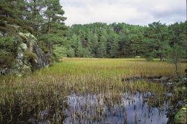
Vernøya
If you smell a foul smell out in nature, you mustn't immediately think that the reason is cloaca from houses or cabins. The reason can be an entirely natural process that occurs when plants are broken down under special conditions. When there is little oxygen available, hydrogen sulphide can be produced. This is a gas that seeps up from the earth and smells like rotten eggs.

Ånuglo
Take a tour to Ånuglo on a warm summer's day. You can anchor up in Skipavågen and go exploring along the beach. Or, you can find giant holly trees and ivy inland on the island. If you take a trip to the small farms on the west side - one of which is still in operation - you can experience colourful flower meadows from a time most dream of, but few can still remember.


Evanger
Evanger (from Old Norse ålvangr, “vang”, “voll” (field) where the horses may graze) is the place where the river from Vangsvatnet, the Voss watercourse, runs out into Evangervatnet. From here Teigdalen valley runs to the north, towards Eksingedalen, and from here there is a short distance to Bergsdalen in the south.

