- Remove Quarns and mills filter Quarns and mills
- Remove Trading posts and guesthouses filter Trading posts and guesthouses
- Remove Wetland filter Wetland
- Remove Vernacular arts filter Vernacular arts
- Remove Vernacular crafts filter Vernacular crafts
- Remove Factories filter Factories

Vinnesleira
Bays that are shallow far out into the sea, with fine sand and clay, are rare in Hordaland. Where they are found, the reason is usually that the edge of the glacier made smaller advances or stopovers when it calved back at the end of the last Ice Age. This is what happened at Vinnesleira.

Heggjagarden
The transport exchange on the farm Vik in Eidfjord was an important part of the communication network in older times. This is where people secured transport by boat out in the fjord, those travelling across the mountain from east and down into Måbødalen. The transport exchange was situated at “Wiige grund”. Today the highway cuts through the farmyard; the main farmhouse from the 1800s lies on the upper side of the road, the large sea-house, with a bakery in former times, lies close to the fjord.

Langavassmyrane
The Ruff lek on Langvassmyrane is the only known phenomenon of its kind on Hardangervidda. Every year it attracts hens from the whole plateau. The marsh is also the richest wetland in the county. This green oasis is located in a rocky moraine landscape a few hours walking distance south of Dyranut.

Granvinsvassdraget
After the ice age, Granvin Fjord reached all the way up under Skjervsfjossen waterfall. Just a thousand years later, as a result of the rising of the land after the ice melted, this whole inner part of the fjord freed itself of the sea and became Granvinsvatnet lake. In spite of this rise in elevation, this waterway is still navigable for fish: Sea trout have wandered into Granvinsvatnet in more recent times and evolved to become freshwater trout. And salmon and sea trout made the journey 13 kilometres up the Storelvi river.

Kjerland
On the farms Kjerland and Røynstrond, east of the river that flows into the fjord, we find many decorative painters who belong to the so-called sòlekistemålarane in Hardanger: Knut and Mikkjel Røynstrand and Johannes Jonsson Kjærland.

Kongstun
In the Middle Ages the farmers were under obligation to transport state officials. The bishops were entitled to 18 horses when they travelled about on visitations, and the king could requisition free transport.

Nedre Folkedal
For many years the Folkedal scythe had a good reputation. Immediately above the highway through Folkedal there is a long brick building, on the inner side of the river. Here production of scythes went on to the beginning of the 1950s.

Ulvikapollen
When the lush beach area innermost in Ulvikapollen was protected, the bird life was instrumental to the decision. The plant diversity is just as impressive. In Hordaland sea meadows such as this are rare small in size - they are more common in coastal environments.
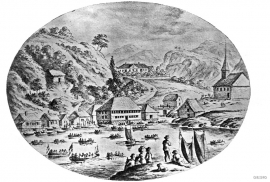
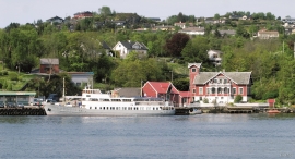
Strusshamn
On the south side of Askøy, just west of Bergen, lies Strusshamn. The sheltered bay is one of the best harbours in Byfjorden, on the route south. At the time of the sailing ships the harbour could be full of vessels from Bergen and abroad, lying in wait for favourable wind. Old anchoring rings from 1687 bear witness to this. Strusshamn was a quarantine harbour for ships that came sailing in with the yellow pest flag flying.
Brattholmen
The old guesthouse location in Brattholmen on the east side of Litlesotra, was probably established in the first half of the 1700s. A list from 1748 mentions that the place “for some years has been inhabited by an Enrolled Sailor by the name of Peder Michelsen”. As was the case for most other military hosts, he was exempt from paying income tax.

