- Remove Quarns and mills filter Quarns and mills
- Remove Civil servant dwellings and manors filter Civil servant dwellings and manors
- Remove Burial mounds filter Burial mounds
- Remove Bronze age filter Bronze age
- Remove Mineral resources filter Mineral resources
- Remove Faults filter Faults
- Remove Waterfalls filter Waterfalls


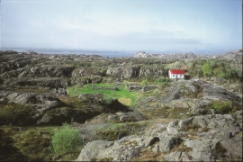
Frekhaug
Frekhaug has been a large farm with well-off owners through many generations. The main house, a two storey building with a hipped roof, must have been erected about 1780.

Toska
The peat bogs on Toska have been mined for peat since 1946, when the island got electricity. In this treeless coastal landscape, peat was the most important source of energy, and this took quite a toll on the bogs.

Vågenes
On Vågenes, on one of the prominences out toward Eitrevågen, one finds garnets in anorthosite. The garnets are both older, and not least bigger, than average.


Lykling- gold
During the summer of 1979 a rock was found at Lykling in Bømlo that contained 450 grams of gold, and at the end of the 1980s a great many gold samples were laid out for sale. In the old mining area there are still gold miners hunting for the precious metal. But, the big adventure stories are a thing of the past.

Helgaberget
Helgaberget – the holy hill – is a little rocky crag which thrusts itself a few metres above the terraced surface of Støle. The surface of the rock is strewn with figures inscribed in the rock and it was, as far as one can judge, a cult centre in the Bronze Ages. The name could indicate that the tradition of holiness can have lasted for almost 3,000 years.


Fitjarøyane
If we study the group of islands south of Selbjørns Fjord from the air or on a sea map, we will notice that many of the islands are elongated and lie systematically in rows. The islands are divided by long sounds, for example Trollosen, Nuleia and Hjelmosen, which are oriented in a south-southeast to north-northwesterly direction.

