- Remove Smallholdings filter Smallholdings
- Remove Large landforms filter Large landforms
- Remove Archaeological findings filter Archaeological findings
- Remove Fisheries filter Fisheries
- Remove Waterfalls filter Waterfalls
- Remove Museum filter Museum
- Remove Farm sites filter Farm sites
- Remove Lakes, rivers and river networks filter Lakes, rivers and river networks

Hopland
The farmhouses at holding No. 15 at Hopland are built together to form a long, continuous building, with dwelling house, hayshed and cowshed built in one row. There have been many such joined structures in the coastal communities, but today there are few remaining. If we travel to the other side of the North Sea, to the Faeroes, Shetland and the Orkney Islands, we find corresponding features in the older building traditions. We find ourselves in a large North Atlantic cultural area.

Isdal
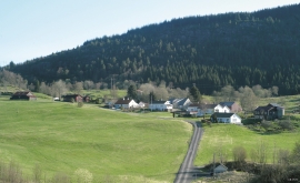
Isdal one of the few clustered settlements left in the Hordaland communities, after the extensive changes taking place around the turn of the former century, which broke up the shared farms and the old intermixture of strips. The old, low houses are situated in a compact enclosure, which is very noticeable in the landscape when you travel the main road north from Knarrvik.


Lurekalven
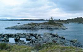
Lurekalven is an unpopulated island of heather moor which is a part of the wilderness belonging to the five farms on Ytre Lygra. Between the two islands there is only a small sound. As late as the 1920s, milking cows were rowed over the sound from Lygra in summer – a form of farming that was adapted to the coastal landscape.


Dyrdal
If you journey along Austfjorden, you at the same time turn the pages of time back through Ice Age history. The landforms show how the landscape has developed gradually as the glaciers have grown - and melted again - in several episodes: from small cirques, we see innermost at Dyrdal, to larger fjords, like at Mas fjord further out.


Matrehola
On a large gravel terrace in Matredalen (the Matre valley), a couple of kilometres from the coastal settlement Matre, lies Storseterhilleren, at the end of a large stone block that came rushing down from the mountain. The Matre river runs just over 100 metres to the east of the cave.

