- Remove Small landforms filter Small landforms
- Remove Middle age filter Middle age
- Remove Eidfjord filter Eidfjord
- Remove Large landforms filter Large landforms
- Remove Fusa, frå 2020 ein del av nye Bjørnafjorden kommune filter Fusa, frå 2020 ein del av nye Bjørnafjorden kommune
- Remove Trading posts and guesthouses filter Trading posts and guesthouses
- Remove Lakes, rivers and river networks filter Lakes, rivers and river networks
- Remove Voss, frå 2020 del av nye Voss herad. filter Voss, frå 2020 del av nye Voss herad.
- Remove Literature filter Literature
- Remove Quarries filter Quarries

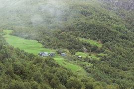
Simadalen
On the 10th of August, 1937, over half of the agricultural land in Simadalen was submerged by the river. The damage to roads and houses was also catastrophic. This was the most destructive flood ever recorded in Hordaland.


Bolstad
The village at Bolstadøyri acquired its structure around the middle of the 1800s, but from the old days there has been a meeting place here; court location and trading post. The guesthouse place stems from the second half of the 17th century, and in the previous century Bolstadøyri was one of the largest rural trading posts in Nordhordland.

Bordalsgjelet
Deep down between the stone polished phyllite bedrock in Bordalsgjelet canyon, there is a cascading river. In close cooperation with hard polishing stones, the water has carved into the bedrock for thousands of years - and is still doing so today.

Finne
Peter Bonde, who owned Finne towards the end of the 1200s, had a jumping stag in his family emblem. This stag is the origin for the heraldic blazon of Voss. Peter Bonde and his descendants acquired possession of many farms and farm parts; the so-called Finne properties became some of the largest land properties in the country.


Hamlagrø
The type of underlying rock can be decisive for how many different types of plants are found in an area. In the area around Hamlagrø-lake the diversity is especially obvious. The geological conditions change much here within a short distance.


