- Remove Small landforms filter Small landforms
- Remove Churches filter Churches
- Remove Bronze age filter Bronze age
- Remove Maritime environments filter Maritime environments
- Remove Cultural landscapes filter Cultural landscapes
- Remove Iron age filter Iron age
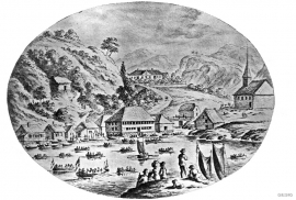
Strusshamn
On the south side of Askøy, just west of Bergen, lies Strusshamn. The sheltered bay is one of the best harbours in Byfjorden, on the route south. At the time of the sailing ships the harbour could be full of vessels from Bergen and abroad, lying in wait for favourable wind. Old anchoring rings from 1687 bear witness to this. Strusshamn was a quarantine harbour for ships that came sailing in with the yellow pest flag flying.

Landro
Landro has been the largest estate on Sotra, including 15 farms with reasonable conditions for agriculture. Their boathouses have had an excellent harbour in Landrovågen. Landro thus has been a good basis for the combination of agriculture and fishing.

Fossen Bratte
The steep drop by Fossen cliff has been the biggest challenge for those who wished to make a road over Kvamskogen through the years. Leave the car by the monument on the old road and take a walk down to the bend by the waterfall that Bergen-folk call "The bridal veil". Why is there a waterfall just here?


Notaholmen
The fishnet shed at Notaholmen stands as a reminder of the days when people used to row out on the fjord to set their nets. On Notaholmen the nets were dried, repaired and tanned. And it was a great advantage to store them in a place inaccessible for rats and mice.

Ådland
Ådland, innermost in the Samnanger Fjord is an old church centre and transport centre; a nodal point in the transport from sea to land. The white painted church standing today, was built in 1851, but there were two older churches here in former centuries.

Golta- Long house
In the years between the wars a major registration of houses and house costumes, house construction methods, fireplaces and forms of housing clusters was started in West Norway – an ambitious mapping of everything that came under the name “Registration of Culture and Geography in West Norway”. One of the places of which material was gathered in 1938 was an old multi-room house at Golta; new and interesting material for the researchers from the Historical Museum, but well known within the local building tradition through several generations.

Goltasundet
For generations the land-seine was the most important tool for catching herring and mackerel, and therefore a suitable casting bay was worth its weight in gold. Goltasundet (the Golta sound) on Golta was such a place. Here the herring often drifted in and fantastic casts might be made here.

