- Remove Small landforms filter Small landforms
- Remove Museum filter Museum
- Remove Late glacial filter Late glacial
- Remove Faults filter Faults
- Remove Tourism filter Tourism
- Remove Conservation area filter Conservation area

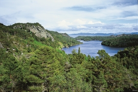
Skogafjellet
You have to travel to Scotland in order to find pine forests similar to those at Bømlo. The nearness to the sea has contributed in different ways to shaping one of the westernmost pine forests in Norway.


The village of Etne
Much of the sand and gravel that the town of Etne is built on was laid down at the end of the Ice Age and is evidence of melting glaciers and roaring meltwater rivers. The uncompacted material in the big terraces leave their unmistakeable mark on the wide elongated valleys.


Fitjarøyane
If we study the group of islands south of Selbjørns Fjord from the air or on a sea map, we will notice that many of the islands are elongated and lie systematically in rows. The islands are divided by long sounds, for example Trollosen, Nuleia and Hjelmosen, which are oriented in a south-southeast to north-northwesterly direction.

Fitjar- potatoes
The deep agricultural soils in Fitjar are found especially in the area between Lake Storavatnet and Breivika. The many stonewalls in the area reflect that the earth probably was full of stones and stone blocks. The stones that couldn't be dug out had also a function: they stored heat that helped to grow potatoes.

Rimbareid- Vestbøstad
At nesting time you cannot avoid hearing the calls of the curlew or the snipe along the narrow road through the cultural landscape from Rimbareid to Vestbøstad. And on late summer evenings, the intense song of the sedge warbler rings out over the two characteristic tarns in the area.

