- Remove Small landforms filter Small landforms
- Remove Boat- and shipyards filter Boat- and shipyards
- Remove Basement rocks filter Basement rocks
- Remove Nordhordland filter Nordhordland
- Remove Large landforms filter Large landforms
- Remove Place filter Place
- Remove Road constructions filter Road constructions
- Remove Fish filter Fish
- Remove Midthordland filter Midthordland

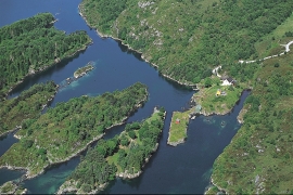
Dyrdal
If you journey along Austfjorden, you at the same time turn the pages of time back through Ice Age history. The landforms show how the landscape has developed gradually as the glaciers have grown - and melted again - in several episodes: from small cirques, we see innermost at Dyrdal, to larger fjords, like at Mas fjord further out.
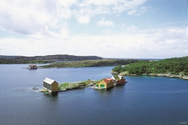
Lure Fjord
Both Lure Fjord and Lindåsosane to the inside give good living conditions for rare marine organisms: jellyfish, shellfish and fish. These include animals that migrated in after last the Ice Age, when the sea level was higher. Eventually, as the land rose, some of these populations became isolated.

Rylandvassdraget
There is a lot of trout and a large char population in Lake Rylandsvatnet. The lake was stocked with char, probably in 1907. The promoters of the project were the family Ameln, who owned eight mills in Rylandsvågen and parts of the Ryland farm.

Eldsfjellet
The eclogites in western Norway were formed when Precambrian basement rocks were squeezed and pressed down under great pressure deep under the Caledonian mountain chain. The process may well have triggered some of the deepest earthquakes the world has ever known. The clearest traces of this drama are found in and around Mt. Eldsfjellet, in peaceful Meland.


Haganes
The gneiss landscape west and north of Bergen viewed in profile can remind us of a saw blade of the kind that has long, slanted sides that get broken off shorter transverse sides. It has taken several hundred million years to file this saw blade, an enduring interplay between various geological processes.
Glesvær
He wondered, surely, the fisherman who in 1769 found a 3.3 metre-long silvery shining sea creature at Glesvær. Perhaps he hadn't heard the legend about the sea snake. If so, he must have thought that that was what he had found, for the sea creature resembled more a fantasy figure of a sea snake than any fish he had ever seen.

Golta- Gneiss
Over thousands of years, autumn storms and strong land-driving winds have cleaned the bare rocks of Golta. The waves can beat far in over land and make it dangerous to walk along the shoreline. When the storms have calmed, the results of their work comes into view.


