- Remove Small landforms filter Small landforms
- Remove Lakes, rivers and river networks filter Lakes, rivers and river networks
- Remove Voss, frå 2020 del av nye Voss herad. filter Voss, frå 2020 del av nye Voss herad.
- Remove Fitjar filter Fitjar
- Remove Farm sites filter Farm sites
- Remove Trading posts and guesthouses filter Trading posts and guesthouses


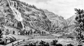
Stalheim
Stalheim is situated between Stalheimsfossen and Sivlefossen, in a community with the farms Sivle and Brekke. The most likely explanation of the name is “the farm by Stadall”, from “standa” (stand), probably with background in the steep Stalheimskleivi. The farm has for a long time been divided into several units. At Stalheim there has been a transport exchange from the Middle Ages and the farm has been a postal farm since 1647.

Staup
The farm STAUP lies on a shelf in the terrain above Løno. From the highway E16 it is possible to glimpse the houses through the trees. The farm is without a road, and the old farmyard and the cultural landscape is very well preserved. In the 1980s grants were given to carry out maintenance work with the intention of protecting the houses in the farmyard.
Tvinne
Following the introduction of fixed postal deliveries in Norway from 1647, post farms were appointed where the farmer was under obligation to bring the post to the next post farm. The farm Ttvinne is situated 12km from Rogne, the next post farm to the west, and about the same distance from Vinje. Later on a transport station was established at Vinje with the possibility for overnight stay for travellers, and from the 1830s, a hotel.


The Vosso river network
The Vosso is Hordaland's main artery, she has never run more richly than in our times, and no other river in western Norway carries so much water. The increase in the amount of water comes mainly from hydropower development, due to the transfer of water from other water systems. Climate change can also be a reason that the Vosso carries more water than before.

