- Remove Small landforms filter Small landforms
- Remove Sediments filter Sediments
- Remove Boat- and shipyards filter Boat- and shipyards
- Remove Avalanches and rock falls filter Avalanches and rock falls
- Remove Mountain plants filter Mountain plants
- Remove Trading posts and guesthouses filter Trading posts and guesthouses
- Remove Plants by the sea filter Plants by the sea

Salhus
Salhus has been a connecting point for sea travellers far back in time. The name probably derives from the Old Norse word sáluhús, “house for travellers”. The name may indicate that this was a place for an inn even in the Middle Ages. The place is eminently situated in the route to and from Bergen. For travellers coming by boat from Sogn and Nordhordland, Salhus is the last stop before Bergen. Travellers from the communities in Voss also came this way earlier when they were going to Bergen

Sandviken
Close to the tunnel opening at Amalie Skrams vei in Ssandviken, there is a cultural monument of European dimensions; a rope making works that produced rope and fishing tackle for West and North Norway.

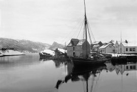
Verftet
Today the name “Verftet” is linked to both a district and conglomeration of buildings lying protected by Fredriksberg castle. The original shipyard was founded in the 1780s by Georg Brunchorst and Georg Vedeler. It was called Gerogenes Verft (the shipyards of the Georgs), and here ships were both built and repaired in the years after 1786.


Jonstein
When high school student Arne Handegard collected plants for a herbarium in 1962, he didn’t know what kind of rarity he had pressed into his notebook. 30 years later he attended a botanical lecture, where a picture was shown of a plant he recognized: “Norwegian Sagebrush, which in Norway is only found in a large area of Dovre and in Trollheimen, and in a little area in Ry county”. Arne Handegard raised his hand: “That plant grows on Mt. Jonstein in Jondal”.
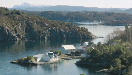
Bakholmen
On Austre Bakholmen, a small islet of around 15 acres between Hundvåko and Drøni, lies the oldest trading centres in Austevoll. For a long time this was a court location and it was a natural centre in this archipelago.

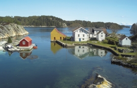
Krosshamn
Krosshamn lies in the shipping lane northeast of Hundvåkøy, near Sandtorv. The name probably derives from the fact that this is Austevoll’s harbour situated nearest to Korsfjorden.

