- Remove Small landforms filter Small landforms
- Remove Middle age filter Middle age
- Remove Maritime environments filter Maritime environments
- Remove Defense filter Defense
- Remove Place filter Place
- Remove Churches filter Churches
- Remove Trading posts and guesthouses filter Trading posts and guesthouses

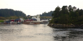
Håøy
Håøy lies centrally in one of the main shipping lanes going into Bergen --- with Håyøsund on the south side facing Meland, and Hagelsundet facing Lindåslandet. Names like Nordfarskista and Nordfarsskorane explain things. The strategic position was important in Viking times and it has been important in our days too. The beacon on Håøy can have been built in the establishment of the coastal administration in Håkon the Good’s time, about 950 AD. The defence structure of which we say remains on Håøy Summit held a critical position during Norwegian neutrality during the First World War. The defence structure was taken down in 1957.

Holmeknappen
If you come by sea to Bergen and come up the Herdle Fjord, the yellow ochre marine shed at Holmeknappen is a well known landmark to starboard as you come close to the little shore settlement. In olden days Holmenknappen served important functions as a centre for a wide hinterland of the surrounding farms, warehouse, landing point, country store and later a steamer quay, a hotel (1896) and a dairy (1909). But today Holmeknappen is no longer a focal point. Transport and commercial routes have changed the old pattern
Kjelstraumen
If you take the sea route north you have several options. The various routes have been dealt with in history, and through the Middle Ages the traffic increased as well as the trading with Nordland in fish and herring, feather and down. One of the central routes passes through Kjelstraumen, in the sound between Ulvøy and Bakkøy. This has been a place for a guesthouse since 1610, with Royal Letter of Privilege, part of the large network of trading post and guesthouse locations along the coast.

Krossøy
Furthest north in the island community Rongevær, at the entrance to Fensfjorden, lies Krossøy. Belonging to the farm are the islands of Krossøy, Husøy, Kårøy, Lyngkjerringa, Søre Kjerringa, Rotøy and Kuhovet. All of them have been inhabited. On Krossøy itself today there are four holdings. The marine use environment here is one of the best preserved along the West Norwegian coast.

Kræmmerholmen
Kræmmerholmen is one of the old privileged trading posts. From the 1600s all trading in West Norway took place in Bergen, and the farmers were obliged to travel into town in order to sell their produce and buy what they needed. In Bergen City Privilege of 1702 the merchants in the city were allowed to establish “Trading posts in the countryside”. The owner had to have residency in Bergen and the trading post was to be run by an assistant. In this way the city retained financial control of those living in the districts, and not least with buying and selling of fish.

Vinappen
Vinappen lies on a low hill to the very west on the island. Here you have an amazing panorama of the sea. Originally the area was grazing land for cattle, but this changed when the Germans occupied the island. Just before WWII there was a small bearing station, used by the Norwegian Coast Artillery in connection with exercises at sea.

Storegraven
The first mention of Granvin church in written sources is in 1306, but the church location must be far older than this. The farm Storegraven is centrally situated at Granvinsvatnet, by the important traffic artery between Hardanger and Voss, where the road takes off to Ulvik.

Kongstun
In the Middle Ages the farmers were under obligation to transport state officials. The bishops were entitled to 18 horses when they travelled about on visitations, and the king could requisition free transport.

Øvre Folkedal
Folkedal, which today is like a small “detour” from the main highway, was in the Middle Ages centrally situated in one of the most important roads between Hardanger and Voss. This is the road that Olav Haraldsson travelled in 1023, when he came from the royal farm at Avaldsnes for a meeting with the Voss inhabitants about the new belief. The road passes across the mountain pasture Krossaset and down Bordalen to Vangen.

Matrehola
On a large gravel terrace in Matredalen (the Matre valley), a couple of kilometres from the coastal settlement Matre, lies Storseterhilleren, at the end of a large stone block that came rushing down from the mountain. The Matre river runs just over 100 metres to the east of the cave.

