- Remove Hydro power filter Hydro power
- Remove Sedimentary rocks filter Sedimentary rocks
- Remove Bronze age filter Bronze age
![Dale power station](https://www.grind.no/sites/default/files/styles/medium/public/bilder/sted/232/kvh_333-4xx.jpg?itok=Y26ZxQM5)
Dale power station
In 1923 Bergenshalvøens Kommunale Kraftselskap (BKK) expropriated large areas for power plants and development of hydropower started soon afterwards. Dale power station with the two first aggregates, each of 14 MW was put into operation on 17 November 1927. In the supply reservoir in Storefossen 5152 cubic metres of concrete were cast, and a modern and well-equipped power station was built.
![The wheelhouse at Hovdanes, Tysnes](https://www.grind.no/sites/default/files/styles/medium/public/bilder/sted/232/kvh_224-3.jpg?itok=hDerF4kE)
![Håhaugsteinen](https://www.grind.no/sites/default/files/styles/medium/public/bilder/sted/232/kvh_388-2.jpg?itok=DKaS4quO)
![The rock carvings at Bakko.](https://www.grind.no/sites/default/files/styles/medium/public/bilder/sted/190/kvh_384-23.jpg?itok=SkUv1D2l)
Bakko
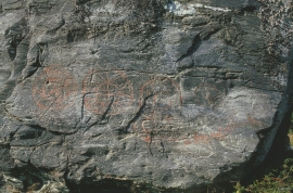
Everyone knows the famous painting by Tidemand & Gude “Brudeferden i Hardanger” (The Wedding Party in Hardanger) one of the great icons in the National Gallery. Some have, in a humorous lack of respect for this masterpiece linked the concept of “bride’s passage” to another pictorial presentation in Hardanger. This is found on the farm Bakko in Herand, carved in the rock by an unknown artist around 3,000 years ago.
![Bronze find from Ålvik](https://www.grind.no/sites/default/files/styles/medium/public/bilder/sted/232/kvh_369-1.jpg?itok=peU4UYwl)
![The power station at Herlandsfossen, Osterøy](https://www.grind.no/sites/default/files/styles/medium/public/bilder/sted/232/kvh_327-4.jpg?itok=UYh1p6Mj)
![Drawing of runic letters engraved in a carving knife from Fløksand.](https://www.grind.no/sites/default/files/styles/medium/public/bilder/sted/190/linalaukrf.gif?itok=9G3iwJhY)
![Sysendammen](https://www.grind.no/sites/default/files/styles/medium/public/bilder/sted/232/eid_37.jpg?itok=ibwv5qBG)
![On the trail toward Kyrkjedøri, a half hour walk from Finse station, we find these small ridges](https://www.grind.no/sites/default/files/styles/medium/public/bilder/sted/232/ulvik_12.jpg?itok=gpoawGzE)
Trail toward Kyrkjedøri
Roughly 550 million years ago, what is now Finse lay at the bottom of the sea - the remains of mud and clay that were deposited in this sea have ended up on the roofs of Norway. Also the thrust sheet from the continental collision has found its way to Finse, after a several hundred kilometre-long, trek through the mountains, that took several tens of millions of years to complete.
![Fossil scree](https://www.grind.no/sites/default/files/styles/medium/public/bilder/sted/232/ulvik_10.jpg?itok=4OVfBQkN)