- Remove Cultural landscapes filter Cultural landscapes
- Remove Samnanger filter Samnanger
- Remove Hydro power filter Hydro power
- Remove Kvinnherad filter Kvinnherad
- Remove Tourism filter Tourism
- Remove Ulvik filter Ulvik
- Remove Middle age filter Middle age
- Remove Stord filter Stord

Bondhusdalen
The Bondhus area in Maruanger has been a magnet for tourists ever since the stream of tourists to Norway's west coast began in the middle of the 1800s. The magnificent landscape with the "ice trail" up to Bondhusvatnet Lake, the ice falls from Bondhusbreen glacier and Keisarstigen trail up to Folgefonna are still popular tourist attractions.


Halsnøy Monastery
Halsnøy Monastery is situated in the midst of the lush fjord country in Sunnhordland, on one of the old spits, or “necks”, that has given name to the island. Gently sloping fields lead down to the sea on both sides, in the south towards the Kloster Fjord, to the north towards the sheltered Klostervågen.
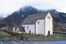
Kvinnherad Church
The stately Kvinnherad Church with its characteristic profile set out against the mighty Malmangernuten in the background, gives you a rare feeling of being present in a historic landscape as you come around Nes and face the well-kept houses at the Skåla farm. The church at Skåla is one of four “fjordungskirker” (one of four main district churches) and this farm was the centre of this coastal administration district.


Osa
At the bottom of the Osa fjord there is a cultural landscape marked by great contrasts; the wide terraces and the river delta at the fjord contrast with the steep hillsides in the background, where Norddalen leads up to the mountain. There are two farms here. Osa and Sævartveit – the farm at the river mouth and the hollow by the sea.


Frøland
Much rain, a steep drop and nearness to Bergen meant that the power-making potential of the Samnanger water system was exploited early. Samnanger was thus one of the first power-producing municipalities in western Norway. With its subsequent expansion and new power stations, about 400 gigawatts of electricity per hour were produced on average each year. This is enough to meet the energy needs of 25,000 households.


Ådlandsstova
The Ådland house is one of the biggest medieval houses still existing in West Norway. It is constructed from unusually large, hard fir wood, beautifully oval-cut. One story links the cottage to the Gildeskålbakken at Orninggård (Lower Ådland); thus indicating that the cottage has been the medieval banqueting hall. The building has been dated back to the 13-1400s by carbon dating.

