- Remove Cultural landscapes filter Cultural landscapes
- Remove Samnanger filter Samnanger
- Remove Voss, frå 2020 del av nye Voss herad. filter Voss, frå 2020 del av nye Voss herad.
- Remove Archaeological findings filter Archaeological findings
- Remove Chieftains and royal lines filter Chieftains and royal lines
- Remove Ulvik filter Ulvik
- Remove Os, frå 2020 del av nye Bjørnafjorden kommune filter Os, frå 2020 del av nye Bjørnafjorden kommune
- Remove Etne filter Etne
- Remove Øygarden, frå 2020 del av nye Øygarden kommune. filter Øygarden, frå 2020 del av nye Øygarden kommune.
- Remove Farm sites filter Farm sites

Frøystein
The farm Frøystein by the Ulvik fjord is commonly called Fryste. In 1614 the name was written Frøstemb – an obvious Danish influence – and the form Frøsten was used up until the land register in 1886 and 1907. It is probable that the name of the farm originally was Frystvin; a vin-name. Thus it has no connection with neither Frøy (Norse fertility god) nor stein (stone).

Osa
At the bottom of the Osa fjord there is a cultural landscape marked by great contrasts; the wide terraces and the river delta at the fjord contrast with the steep hillsides in the background, where Norddalen leads up to the mountain. There are two farms here. Osa and Sævartveit – the farm at the river mouth and the hollow by the sea.


Blomvågen
"One of the big scientific sensations", was the title in the Bergens Times newspaper on the 22nd of November, 1941. It was the geologist Isal Undås who had been interviewed by the newspaper. He thought that he had discovered a 120 000 year old whale bone, remains of life from before the last Ice Age.
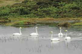
Tjeldstømarka
There is no place in Hordaland where there are so many over-wintering song swans as in Tjeldstømarka. And there are few places in the county that have had this birdfowl as a guest for as long.

Støle
High above the sea and the beach flats, on one of the wide terraces shaped by the sea and the ice, lies the farm Støle (Stødle). The Old Norse name of Studla is derived from studill “support, shelf”. As far back as Viking times Støle has been a chieftain’s farm, a good farm on the plains formed by the moraine masses.

Stordalen
When the Etne water system was protected in 1994, preservation of the cultural landscape in Stordalen Valley was a a main objective. This is a valley with an exceptional abundance of Different types of plants and animals. In the grey alder forest in Stordalen there are more bird species than in most other places, in fact, denser than one tends to find in a tropical rainforest.

Byrkjehaugen
On the farm Bø, close to the highway between Bulken and Voss lies Byrkjehaugen, one of the largest burial mounds in West Norway. Originally it was around 50m across and 5m high, but following the excavation in 1908 and chipping off by both railway and road construction, the cross-section has shrunk to 37m and the height to 4m. All the same, it is an impressive burial monument for the passing traveller to see.

