- Remove Cultural landscapes filter Cultural landscapes
- Remove Samnanger filter Samnanger
- Remove Voss, frå 2020 del av nye Voss herad. filter Voss, frå 2020 del av nye Voss herad.
- Remove Kvinnherad filter Kvinnherad
- Remove Tourism filter Tourism
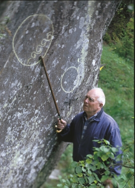
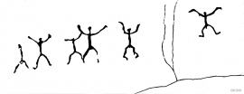
- Remove Rock carvings filter Rock carvings
- Remove Mountain farms filter Mountain farms
- Remove Osterøy filter Osterøy

Bondhusdalen
The Bondhus area in Maruanger has been a magnet for tourists ever since the stream of tourists to Norway's west coast began in the middle of the 1800s. The magnificent landscape with the "ice trail" up to Bondhusvatnet Lake, the ice falls from Bondhusbreen glacier and Keisarstigen trail up to Folgefonna are still popular tourist attractions.


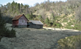
Havrå
In the sunny, steep fjord landscape along Sørfjorden on the east side of Osterøy is the farm Havrå. The small “hamlet” is one of the few undisturbed farming communities that gives us the impression of the large communal yards in West Norway in the 1700s, with houses built close together and strips of arable land.

Holo
I Kvassdalen var det aktiv stølsdrift med mjølking av kyr og geitehald nokre år inn i vårt tusenår, og slik hadde det vore i meir enn to hundre år. Såleis har dalen ikkje fått gro til med kratt og skog, men er open og lys. Fortsett er det beiting av kyr og sauer.


Stalheim
Stalheim is situated between Stalheimsfossen and Sivlefossen, in a community with the farms Sivle and Brekke. The most likely explanation of the name is “the farm by Stadall”, from “standa” (stand), probably with background in the steep Stalheimskleivi. The farm has for a long time been divided into several units. At Stalheim there has been a transport exchange from the Middle Ages and the farm has been a postal farm since 1647.

