- Remove Cultural landscapes filter Cultural landscapes
- Remove Voss, frå 2020 del av nye Voss herad. filter Voss, frå 2020 del av nye Voss herad.
- Remove Archaeological findings filter Archaeological findings
- Remove Chieftains and royal lines filter Chieftains and royal lines
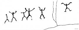
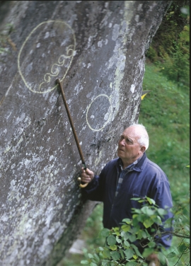
- Remove Rock carvings filter Rock carvings
- Remove Granvin, frå 2020 del av nye Voss herad filter Granvin, frå 2020 del av nye Voss herad
- Remove Hydro power filter Hydro power
- Remove Quarns and mills filter Quarns and mills
- Remove Masfjorden filter Masfjorden


Hummelfossen
As early as 1906 the Matre and Haugsdal waterway was bought up by the businessman Blauuw from Bergen; the first “waterfall speculator” in the Matre area. He immediately resold it to Fr. Hiorth, who transferred all the rights to the company Matrefaldene in 1908. Behind A/S Matrefaldene were German interests, Badische Anilin und Sodafabrik, which wanted to start production of saltpetre fertilizer with nitrogen and electricity.

Matrehola
On a large gravel terrace in Matredalen (the Matre valley), a couple of kilometres from the coastal settlement Matre, lies Storseterhilleren, at the end of a large stone block that came rushing down from the mountain. The Matre river runs just over 100 metres to the east of the cave.


Byrkjehaugen
On the farm Bø, close to the highway between Bulken and Voss lies Byrkjehaugen, one of the largest burial mounds in West Norway. Originally it was around 50m across and 5m high, but following the excavation in 1908 and chipping off by both railway and road construction, the cross-section has shrunk to 37m and the height to 4m. All the same, it is an impressive burial monument for the passing traveller to see.

Rekvemylna
If you enter the farmyard at Rekve, some kilometres from Bulken, where the road departs to Giljarhus, you no longer meet “the miller”, Knut Hernes, in his old rural mill. But some years ago he would wish you welcome, friendly and hospitable, and show you around his mill, which had been his workplace for a generation. As light-footed as a youth he climbed in steep ladders high up into the waterfall, to let the water down on to the waterwheel.