- Remove Middle age filter Middle age
- Remove Vaksdal filter Vaksdal
- Remove Wetland filter Wetland
- Remove Ullensvang, frå 2020 del av nye Ullensvang kommune. filter Ullensvang, frå 2020 del av nye Ullensvang kommune.
- Remove Maritime environments filter Maritime environments
- Remove Nordhordland filter Nordhordland
- Remove Place filter Place
- Remove Hardanger og Voss filter Hardanger og Voss
- Remove Boat- and shipyards filter Boat- and shipyards
- Remove Runestones filter Runestones
- Remove Stone age filter Stone age
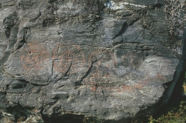
- Remove Rock carvings filter Rock carvings
- Remove Radøy, frå 2020 del av nye Alver kommune. filter Radøy, frå 2020 del av nye Alver kommune.

Toska
The peat bogs on Toska have been mined for peat since 1946, when the island got electricity. In this treeless coastal landscape, peat was the most important source of energy, and this took quite a toll on the bogs.


Skipshelleren
For vel 7000 år sidan var Straume ein av dei beste – om ikkje den beste – veideplassen i Hordaland. Steinalderfolket som busette seg ved Skipshelleren, skjøna truleg ikkje kor heldige dei var. Mellom dei opptil 2 meter tjukke dyngjene med stein og bein som arkeologar grov fram i 1931–32, fann dei reiskapar og avfall frå fangst og matstell. Frå dette materialet har arkeologane stava seg fram til livet ved straumen.

Myking
Between Lake Kvalheimsvatnet and Lake Mykingsvatnet, north of Grindheim, we find one of the biggest continuous lowland bogs in Hordaland. It is 500-600 metres across and a whole 2 kilometres long. Locally, the bog is called "Havet" .


Kinsarvik
Kinsarvik has probably been a centre for the inner Hardanger districts back in prehistory. History tells us that in medieval times there was a marketing place, a “kaupang”, here; a connecting point in the communications between east and west. There were supposedly around 300 residents here but the place was likely wiped out in a great fire.
Jåstad
The farm Jåstad, situated a few kilometres north of Agatunet, must have been a grand farm in medieval times. Torolf on Jåstad is mentioned as arbitration moderator in 1293, and in the vaulted corridor at Lyse Kloster Sigurd, farmer at Jåstad, and his wife Sigrid – the king’s kinswoman - are buried.

Fosnstraumen
At the southern end of the bridge between Radøy and Fosnøy archaeologists found an unusual Stone Age settlement. There was a thick “cultural layer” here with the remains of the waste dumps of a hunting people. The place was called Kotedalen. Here they came, one group after the other, and settled for some weeks, some months, or maybe years before they went on, leaving the settlement deserted. Time after time it happened. At least 16 settlement phases have been identified, stretching over 5,500 years.

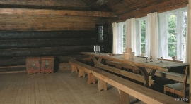
Aga
The grand farm Aga on the west side of Sørfjorden, came under protection in 1937, when the agricultural reform threatened to disperse the old clustered settlement. “Lagmannsstova”, named after the “lagmann” (law speaker) Sigurd Brynjulfsson, was already protected in 1924; one of the authentic profane wooden buildings from the Middle Ages still standing. All the same it is the farmyard itself that is the key cultural monument.

