- Remove Maritime environments filter Maritime environments
- Remove Seabirds filter Seabirds
- Remove Monastery filter Monastery
- Remove Fitjar filter Fitjar
- Remove Ullensvang, frå 2020 del av nye Ullensvang kommune. filter Ullensvang, frå 2020 del av nye Ullensvang kommune.
- Remove Etne filter Etne
- Remove Rock carvings filter Rock carvings
- Remove Large landforms filter Large landforms
- Remove Coniferous forests filter Coniferous forests
- Remove Austrheim filter Austrheim


Fitjarøyane
If we study the group of islands south of Selbjørns Fjord from the air or on a sea map, we will notice that many of the islands are elongated and lie systematically in rows. The islands are divided by long sounds, for example Trollosen, Nuleia and Hjelmosen, which are oriented in a south-southeast to north-northwesterly direction.


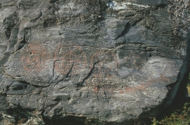
Helgaberget
Helgaberget – the holy hill – is a little rocky crag which thrusts itself a few metres above the terraced surface of Støle. The surface of the rock is strewn with figures inscribed in the rock and it was, as far as one can judge, a cult centre in the Bronze Ages. The name could indicate that the tradition of holiness can have lasted for almost 3,000 years.


Hårteigen
Hårteigen, «the grey signpost», as the name suggests, is a landmark for mountain hikers on the western plateau. The piece of mountain is also a monument for the mighty rock layers that once covered the entire plateau.

Krossøy
Furthest north in the island community Rongevær, at the entrance to Fensfjorden, lies Krossøy. Belonging to the farm are the islands of Krossøy, Husøy, Kårøy, Lyngkjerringa, Søre Kjerringa, Rotøy and Kuhovet. All of them have been inhabited. On Krossøy itself today there are four holdings. The marine use environment here is one of the best preserved along the West Norwegian coast.


