- Remove Quarns and mills filter Quarns and mills
- Remove Basement rocks filter Basement rocks
- Remove Place filter Place
- Remove Hardanger og Voss filter Hardanger og Voss
- Remove Sawmills filter Sawmills
- Remove Lakes, rivers and river networks filter Lakes, rivers and river networks
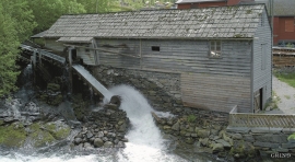
Herand- Tveiti sawmill
Tveiti sawmill in Herand is probably the last water-powered sash-saw in the country that has been in regular operation up to our time. There has been a sash-saw here since the 1700s, and on the other side of the river there are remains of an even older saw.

Krækkjavassdraget
Few other animal species on Hardangervidda have been as much the focus of scientific research as the spotted trout. The spotted trout is considered to be a genetic variant of brown trout. It lives in parts of the Krækkjav water system. Otherwise, on a world scale, this species is only found in a small area in Kaukasus, and possibly also in a lake in Rondane.

Simadalen
On the 10th of August, 1937, over half of the agricultural land in Simadalen was submerged by the river. The damage to roads and houses was also catastrophic. This was the most destructive flood ever recorded in Hordaland.


Granvinsvassdraget
After the ice age, Granvin Fjord reached all the way up under Skjervsfjossen waterfall. Just a thousand years later, as a result of the rising of the land after the ice melted, this whole inner part of the fjord freed itself of the sea and became Granvinsvatnet lake. In spite of this rise in elevation, this waterway is still navigable for fish: Sea trout have wandered into Granvinsvatnet in more recent times and evolved to become freshwater trout. And salmon and sea trout made the journey 13 kilometres up the Storelvi river.

Lussand- geology
Hardangerfjorden kløyver Hordaland i to. Den etter måten rettlinja fjorden skjer seg liksom på skeive inn i landet. Ikkje som Sognefjorden og Nordfjord – dei krokar og buktar seg innover meir eller mindre vinkelrett på kysten. Hardangerfjordens utforming har røter 400 millionar år tilbake i tida, då den veike sona i fjellet, der isen seinare tok grådig for seg, vart danna. Denne sona stig på land ved Lussand.

Rallarvegen
They rest there, all as one, the silent witnesses of Western Norway's saga of creation: Precambrian basement, phyllite and thrust sheet. In the end came the glaciers and sculptured the vast landscape. Along the ground or on the horizon, from bicycle or on foot - the landscape tells its story - and it tells it clearer on Rallarvegen than many other places.

Solskinstjørni
Solskinstjørni in Osa, just above Haugen farm in Norddalen, is visible only now and again, seemingly always for a period of good weather. Then it disappears abruptly, but its disappearance is not connected to weather conditions.

Berge
Down by the fjord on the farm Berge in Tørvikbygd, is Stekkavika – a sheltered eastward facing harbour, protected against the fjord by headlands and rocks, even manifest in the name. Here is also a comprehensive milieu of coastal industry, with boathouses and sea-sheds that belong to the farms Berge, Heradstveit and Halleråker. Belonging to the farm Berge there is also a mill-house, circular saw, workshop for sloop building, and – a little further up into the woods – the old water-powered sash-saw.


