- Remove Quarns and mills filter Quarns and mills
- Remove Basement rocks filter Basement rocks
- Remove Cultural landscapes filter Cultural landscapes
- Remove Music filter Music
- Remove Museum filter Museum
- Remove Small landforms filter Small landforms
- Remove Maritime environments filter Maritime environments
- Remove Railroad filter Railroad

Rosendal Barony
The Barony of Rosendal lies in the grounds of the old noble estate of Hatteberg, on the north side of the Hatteberg river, around one kilometre up from the sea. The three noble estates Seim, Mel and Hatteberg constituted the core of the large estate taken over by Ludvig Rosenkrantz in 1662, after he was married to Karen Mowat in 1658.
Rød
In 1969 Sigurd and Margreta Dønhaug donated a collection of around 170 historical cultural objects to Kvinnherad municipality. They wanted their gift to become the start of a farm collection in Uskedalen. And that is what happened.

Alvøen
Alvøen is one of the oldest industrial places in Norway. As early as the 1620s a gunpowder mill was built here. The place itself was well situated for industrial activity, lying only 100 m from the waterfall, which provided power for the mill, and a good harbour wherefrom the products were shipped. The success of the gun-powder mill varied in the 1600s and 1700s, but what made Alvøen best known was its paper production.

Bryggen
In the 1300s Bergen was a trading centre of European dimension. The town is thought to have had around 7000 inhabitants and was the largest and most important in the country. In a European context it was an average size town. At this time the most tightly built town area was still mostly east of Vågen from Holmen in the north to Vågsbotn in the south. Already in medieval times, latest in the 1340s, this area was called Bryggen.
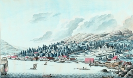
Damsgård
As a fairytale castle Damsgård Hovedgård lies on the slope rising up from the Puddefjord. The old connection between the farm and the sea, as we see it on Dreier’s prospectus from 1810, has been broken up by roads and encroachments in the building mass. But the main building itself is a central monument in Norwegian architecture from the 1700s – one of the finest representatives for the rococo period, with a magnificent and rich décor both in its interior and exterior.

Salhus
Salhus has been a connecting point for sea travellers far back in time. The name probably derives from the Old Norse word sáluhús, “house for travellers”. The name may indicate that this was a place for an inn even in the Middle Ages. The place is eminently situated in the route to and from Bergen. For travellers coming by boat from Sogn and Nordhordland, Salhus is the last stop before Bergen. Travellers from the communities in Voss also came this way earlier when they were going to Bergen

Sandviken
Close to the tunnel opening at Amalie Skrams vei in Ssandviken, there is a cultural monument of European dimensions; a rope making works that produced rope and fishing tackle for West and North Norway.

Svåsand
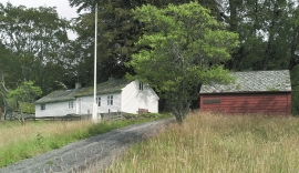
Down by the fjord at Svåsand, close to the main highway, there is a long row of boathouses, one of the well-preserved, older boathouse locations along the Hardanger fjord. It is the farms at Svåsand that have their boathouses here, four main farms with origins far back in time.

Bergensbanen
Already at the beginning of the 1870s demands were made that there had to be a railway connection between Bergen and East Norway. The first section between Bergen and Voss was finished in 1883. The route alternatives further on were many: Lærdal-Valdres, Aurland-Geiteryggen, Raundalen-Finse and Ulvik-Finse. Following a long dispute, an agreement was finally reached that the middle route alternative, Raundalen- Myrdal- Finse, was the best alternative. In 1894 the government passed a resolution that the Bergen railway should be built, but only the section Voss-Taugevatn. This was a political gamble in order to make the rest of the country participate in the plans. In 1898 it was approved that the railway be continued eastwards from Taugevatn to Oslo. This high mountain project was one of the most challenging railway projects in Europe. The Bergen railway was to be built across a mountain plateau without roads.

Osa
At the bottom of the Osa fjord there is a cultural landscape marked by great contrasts; the wide terraces and the river delta at the fjord contrast with the steep hillsides in the background, where Norddalen leads up to the mountain. There are two farms here. Osa and Sævartveit – the farm at the river mouth and the hollow by the sea.

