- Remove Quarns and mills filter Quarns and mills
- Remove Midthordland filter Midthordland
- Remove Pollution and environment filter Pollution and environment
- Remove Hydro power filter Hydro power
- Remove Late glacial filter Late glacial
- Remove Archaeological findings filter Archaeological findings
- Remove Benthic organisms filter Benthic organisms
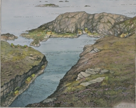

Kvernapollen
When the workers came to Kollsnes to start on the work with the landing for the gas terminal from the Troll field in the North Sea, they found the ruins of an old farm mill at Kvernapollen.


Tyssøy
B.E.Bendixen, who has written about “The Churches in Søndre Bergenhus Amt”, believed even around 1900 that there was evidence at Tyssøy of the church or the chapel of the Holy Ludvig (Louis). Two large stone blocks had lain in the western wall of the church’s nave, and this wall showed a length of 16 meters in the terrain.

Toftestallen
The large coastal waves that crash down on the islands west in the sea gather their energy from storms and winds all the way out in the North Atlantic Ocean. The most common place of origin is nonetheless the North Sea. When these waves break over the skerries and islets along the shore, or on the rocky outermost islands, their energy is released. This takes the form of turbulence in the water and sea spray up on land. Can the enormous energy contained in the waves be exploited?

Blomvågen
"One of the big scientific sensations", was the title in the Bergens Times newspaper on the 22nd of November, 1941. It was the geologist Isal Undås who had been interviewed by the newspaper. He thought that he had discovered a 120 000 year old whale bone, remains of life from before the last Ice Age.

Fjell river network
There are many river networks out by the coast and they tend to be small and unassuming. The farmer has relied upon the watercourses to run his mill and saw, and it may be that the trout have given him a good source of food in years when the ocean fish failed. In our time, these river networks are being rediscovered for their value in recreation and outdoor life, and several places, tourist trails have been built in order to fully enjoy them.
Kollevågen
From 1938 until 1975 there was a large amount of trash dumped in Kollevågen. A lot of the garbage from the city of Bergen ended up here. The dump was up to 20 metres high, and much got dumped under water in the bay. When the dump was closed, the time had come to make good on a municipal promise to make the place into a recreation area. In 1978, nets and earth were laid over the dump, and afterward it was sowed with seeds. This was quite successful, and In 1983, the recreation area was opened.

Herdla – glacial deposits
The shift in the landscape is striking between the barren craggy moors north on Askøy and the green fields of Herdla, which has the county's biggest farm. The majority of Herdla, such as the island appears today, is a gift from the glacier: The glacier that advanced here over 12,000 years ago stopped at the northern tip of Askøy and took its time building up the moraine on Herdla. Since then, Herdla has been under continual transformation. The re-organisation of the loose sediment deposits continues today.

Frøland
Much rain, a steep drop and nearness to Bergen meant that the power-making potential of the Samnanger water system was exploited early. Samnanger was thus one of the first power-producing municipalities in western Norway. With its subsequent expansion and new power stations, about 400 gigawatts of electricity per hour were produced on average each year. This is enough to meet the energy needs of 25,000 households.

