- Remove Smallholdings filter Smallholdings
- Remove Place filter Place
- Remove Lakes, rivers and river networks filter Lakes, rivers and river networks
- Remove Wetland filter Wetland
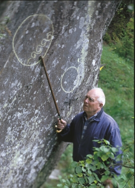
- Remove Rock carvings filter Rock carvings
![Klokkarvatnet](https://www.grind.no/sites/default/files/styles/medium/public/bilder/sted/190/klokkarvatnet.jpg?itok=7CkW0qZ8)
![Håhaugsteinen](https://www.grind.no/sites/default/files/styles/medium/public/bilder/sted/232/kvh_388-2.jpg?itok=DKaS4quO)
![The rock carvings at Bakko.](https://www.grind.no/sites/default/files/styles/medium/public/bilder/sted/190/kvh_384-23.jpg?itok=SkUv1D2l)
Bakko
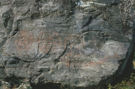
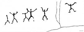
Everyone knows the famous painting by Tidemand & Gude “Brudeferden i Hardanger” (The Wedding Party in Hardanger) one of the great icons in the National Gallery. Some have, in a humorous lack of respect for this masterpiece linked the concept of “bride’s passage” to another pictorial presentation in Hardanger. This is found on the farm Bakko in Herand, carved in the rock by an unknown artist around 3,000 years ago.
![The rock painting “running dog”](https://www.grind.no/sites/default/files/styles/medium/public/bilder/sted/232/kvh_352-4.jpg?itok=nlTkE3N6)
![Sledasteinen, Voss](https://www.grind.no/sites/default/files/styles/medium/public/bilder/sted/232/kvh_349-4.jpg?itok=Ob47Q6Tw)
![Ystebøtræet, Radøy](https://www.grind.no/sites/default/files/styles/medium/public/bilder/sted/232/kvh_301-1.jpg?itok=mqbwhdA8)
![Langavassmyrane looking towards Langavatn.](https://www.grind.no/sites/default/files/styles/medium/public/bilder/sted/232/eid_39.jpg?itok=TWhBEzeV)
Langavassmyrane
The Ruff lek on Langvassmyrane is the only known phenomenon of its kind on Hardangervidda. Every year it attracts hens from the whole plateau. The marsh is also the richest wetland in the county. This green oasis is located in a rocky moraine landscape a few hours walking distance south of Dyranut.
![Rembesdalsskåka and the lower part of Demmevatnet, from Tresnuten. Demmevass cabin is visible to the left in the picture.](https://www.grind.no/sites/default/files/styles/medium/public/bilder/sted/232/nv_491.jpg?itok=eg8SNPfS)
Simadalen
On the 10th of August, 1937, over half of the agricultural land in Simadalen was submerged by the river. The damage to roads and houses was also catastrophic. This was the most destructive flood ever recorded in Hordaland.
![Grytøyrelva](https://www.grind.no/sites/default/files/styles/medium/public/bilder/sted/232/nv_482.jpg?itok=xhxzmzEq)
![Opo](https://www.grind.no/sites/default/files/styles/medium/public/bilder/sted/232/odda_32.jpg?itok=X8hRVGS1)