- Remove Smallholdings filter Smallholdings
- Remove Vernacular crafts filter Vernacular crafts
- Remove Railroad filter Railroad
- Remove Conservation area filter Conservation area
- Remove Austevoll filter Austevoll
- Remove Fjell, frå 2020 del av nye Øygarden kommune filter Fjell, frå 2020 del av nye Øygarden kommune
- Remove Voss, frå 2020 del av nye Voss herad. filter Voss, frå 2020 del av nye Voss herad.
- Remove Basement rocks filter Basement rocks
- Remove Cemeteries filter Cemeteries


Haganes
The gneiss landscape west and north of Bergen viewed in profile can remind us of a saw blade of the kind that has long, slanted sides that get broken off shorter transverse sides. It has taken several hundred million years to file this saw blade, an enduring interplay between various geological processes.

Løno
Small boat folk in Hordaland know where Løno is. As do many seabirds. With the big ocean at its back and a wide, weather beaten strait ahead of it, Løno is one of Hordaland’s most isolated and exposed recreational areas. The islands west of Sotra are some of the county’s most stable nesting localities for seabirds.
Møvik
In the winter of 1849 the impoverished Fjell municipality was forced to put money into new burial places at Møvik and Bildøydalen, because of the raging cholera epidemic. On 28 March the municipal council decided on a resolution “to apply to His Majesty the King most subserviently to be granted a loan of 500 Speciedaler …”


Evanger
Evanger (from Old Norse ålvangr, “vang”, “voll” (field) where the horses may graze) is the place where the river from Vangsvatnet, the Voss watercourse, runs out into Evangervatnet. From here Teigdalen valley runs to the north, towards Eksingedalen, and from here there is a short distance to Bergsdalen in the south.


Lønaøyane
The Strandaelvi river is forever protected from the development of hydropower. The Lønaøyane islands – which comprise the delta furthest north in Lake Lønavatnet - are a part of this water system. In 1995 the level of protection for the Lønaøyne islands was strengthened to that of a nature preserve because of the rich birdlife in this wetland.

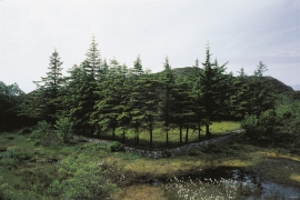
Rekvesøyane
The sediment that was deposited from the river Dyrvo has created the fan-shaped delta Rekvesøyane. The bit of land farthest out toward the water gets periodically flooded, especially during snow melt and after periods of much rain.

