- Remove Smallholdings filter Smallholdings
- Remove Basement rocks filter Basement rocks
- Remove Hardanger og Voss filter Hardanger og Voss
- Remove Mountain farms filter Mountain farms
- Remove Small landforms filter Small landforms
- Remove Tourism filter Tourism
- Remove Quarries filter Quarries
- Remove Sedimentary rocks filter Sedimentary rocks

Agastølen
Whoever wanders the mountain plateau will form time to time hit upon old mountain summer farms, with solid old stone sheds, half sunk into the ground; a building tradition that has roots into prehistoric times. When we have been satiated with untouched Nature, it is somewhat comforting to come upon the old mountain chalets - they represent a type of human encroachment that we not only accept, but appreciate. They arouse a feeling of recognition and are a distinct witness to how people in the rural communities have made use of even the most remote resources.

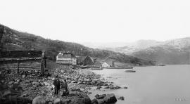
Odda- The tourist town
The pioneering tourists in the 1830s-40s brought a momentum in the tourist traffic to the fjord and mountain country Norway. At the time Odda was a hidden Shangri-La at the bottom of Sørfjorden; the farm and the church on the green headland at the fjord. But when the steamship traffic opened the fjord landscape for tourism, in a few years Odda parish in Søndre Bergenhus County became the focal point for travellers in West Norway.
Utne
When sergeant Peder Larsen Børsem from Strandebarm was “demobilised” in 1721, following the large Nordic War, he married the Bergen lady Elisabeth Schrøder and settled as innkeeper at Utne with a letter of privilege from the county governor dated 29 October 1722.
Måge
Steatite is a type of stone that is abundant in Hardanger. There are large steatite deposits in the mountain below Folgefonna. These deposits are visible both in Krossdalen in Jondal, at Kveitno in Odda and at Måge in Ullensvang. There are many traces of steatite quarrying in Hardanger, and one of the largest fields is in the hillside above Måge.


Lussand- geology
Hardangerfjorden kløyver Hordaland i to. Den etter måten rettlinja fjorden skjer seg liksom på skeive inn i landet. Ikkje som Sognefjorden og Nordfjord – dei krokar og buktar seg innover meir eller mindre vinkelrett på kysten. Hardangerfjordens utforming har røter 400 millionar år tilbake i tida, då den veike sona i fjellet, der isen seinare tok grådig for seg, vart danna. Denne sona stig på land ved Lussand.

Jomfrunuten
Freezing and thawing are processes that influence plant cover, move enormous blocks, stretche long mounds of earth, break open bedrock and create patterns in stone and earth.

Rallarvegen
They rest there, all as one, the silent witnesses of Western Norway's saga of creation: Precambrian basement, phyllite and thrust sheet. In the end came the glaciers and sculptured the vast landscape. Along the ground or on the horizon, from bicycle or on foot - the landscape tells its story - and it tells it clearer on Rallarvegen than many other places.

