- Remove Boat- and shipyards filter Boat- and shipyards
- Remove Late glacial filter Late glacial
- Remove Factories filter Factories
- Remove Faults filter Faults
- Remove Deciduous forests filter Deciduous forests
- Remove Nordhordland filter Nordhordland

Bjørsvik
The industrial settlement Bjørsvik


Eksingedalen- landscape
Eksingedalen alternates between wide, flat flood plains with good farmland, and narrow passages with waterfalls where the roads cling to the mountainsides. The alternations in the landscape are a result of the sculpturing work by glaciers over several ice ages, and the deposition of the glacial river deposits when the last glacier finally melted back.


Mostraumen
Until 1743 the people from Modal had to wait for a flood in MOSTRAUMEN before they could draw their boats up the river current, and then row back across Lake Movatnet. But, that year the flood opened a free passageway all the way to Mo. Hordaland had gained a new tidal waterway.

Nedre Helland- Sand Quarries
The three spades in the municipal coat of arms for Modalen are sand spades. Sand quarrying has brought income and employment. As much as 70,000-80,0000 tonnes of sand and gravel left the municipality each year since the turn of the millennium, to be used as cementing sand. Why is Modalen endowed with so much sand?


Stall
The Bergen Arcs have an unusually sharp boundary to the bedrock in the east. Geologists think that this was caused by movements in the earth's crust during the Devonian Period. Then, the Bergen Arcs on the Lindås peninsula sank a whole 10 kilometres in relation to the Precambrian basement gneisses on the east side of Fens Fjord and Aust Fjord.

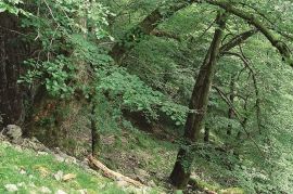
Vollom
On Vollom, northwest of Seim, we find the only natural beech forest in Western Norway, which is also the most northerly of its type in the world. Beech grows also many other places in the county, but these trees are totally lacking in history compared with those of Vollomskogen Forest.

