- Remove Small landforms filter Small landforms
- Remove Cultural landscapes filter Cultural landscapes
- Remove Ulvik filter Ulvik
- Remove Kvam filter Kvam
- Remove Literature filter Literature
- Remove Potholes filter Potholes
- Remove Visual art filter Visual art
- Remove Sediments filter Sediments
- Remove Farm sites filter Farm sites


Jomfrunuten
Freezing and thawing are processes that influence plant cover, move enormous blocks, stretche long mounds of earth, break open bedrock and create patterns in stone and earth.

Rallarvegen
They rest there, all as one, the silent witnesses of Western Norway's saga of creation: Precambrian basement, phyllite and thrust sheet. In the end came the glaciers and sculptured the vast landscape. Along the ground or on the horizon, from bicycle or on foot - the landscape tells its story - and it tells it clearer on Rallarvegen than many other places.

Ulvik-village
The ice cap that covered the land during each of the 40 past ice ages over the past 2 million years of Earth's history pressed down the crust of the earth - like a finger on a rubber ball. And when the ice finally loosened its grip 11,000 years ago, the earth's crust rose again, most where the ice was thickest, least where it was thin, quickly in the beginning, and later more slowly. To this day, the land in the inner part of Norway continues to rise by perhaps one millimetre per year. By and large, however, the crust in Hordaland has again reached equilibrium after the weight of the ice was removed.

Nes
The farm Nes lies directly inside Mundheim on a forested headland in the fjord between Mundheimsvika and Bondesundet, a farm with an attractive and well-kept cultural landscape.
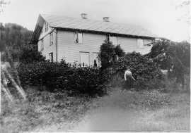
Tangarås
From his loft window on the doctor’s farm at Tangarås the young Hans Ernst Kinck had a view of the fjord and the Mauranger mountains. The fjord settlements in West Norway made a strong impression on the young boy when his family moved from Setesdal, from “the stifling mystique of the ballad”, to Strandebarm in 1876. The new district doctor bought the old captain’s farm at Tangarås, which had for some time been a military head farm after Håbrekke further into the settlement.

Vikøy
Through Adolph Tidemand’s detailed close-ups of smokehouses in Kvam, the vicarage in Vikøy, where he lived during his painting trips through Hardanger, has obtained a central position in the Norwegian national romanticism.

