- Remove Small landforms filter Small landforms
- Remove Cultural landscapes filter Cultural landscapes
- Remove Ulvik filter Ulvik
- Remove Kvam filter Kvam
- Remove Osterøy filter Osterøy
- Remove Metamorphic rocks filter Metamorphic rocks
- Remove Trading posts and guesthouses filter Trading posts and guesthouses
- Remove Jondal, frå 2020 del av nye Ullensvang kommune. filter Jondal, frå 2020 del av nye Ullensvang kommune.
- Remove Quarries filter Quarries
- Remove Vegetation history filter Vegetation history


Jonstein
When high school student Arne Handegard collected plants for a herbarium in 1962, he didn’t know what kind of rarity he had pressed into his notebook. 30 years later he attended a botanical lecture, where a picture was shown of a plant he recognized: “Norwegian Sagebrush, which in Norway is only found in a large area of Dovre and in Trollheimen, and in a little area in Ry county”. Arne Handegard raised his hand: “That plant grows on Mt. Jonstein in Jondal”.

Jomfrunuten
Freezing and thawing are processes that influence plant cover, move enormous blocks, stretche long mounds of earth, break open bedrock and create patterns in stone and earth.

Osa
At the bottom of the Osa fjord there is a cultural landscape marked by great contrasts; the wide terraces and the river delta at the fjord contrast with the steep hillsides in the background, where Norddalen leads up to the mountain. There are two farms here. Osa and Sævartveit – the farm at the river mouth and the hollow by the sea.

Litlandsvatnet
Large quantities of nickel ore have been mined from Litlandsvatnet, between Lonevågen and Hosanger. The discovery was made in 1875. During the period of operation from 1882 to 1945, 4170 tonnes of pure nickel were extracted from 462 000 tonnes of ore, a large production by Norwegian standards.

Botnen
Fyksesundet and Botnagrenda present a fine experience of the landscape and cultural history; a geographically isolated local settlement with extensive cultural contact with the outside world.

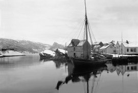
Bru
Bruosen is one of the few river harbours in the county. As landing place for the churchgoers, this place and the boatshed environment follow a tradition that goes back to the Middle Ages, but the country store of today is much younger.

Geitaknottane
Many travellers between Mundheim and Gjermundshamn are captivated by the expansive view toward Øynefjord, Varaldsøy and Folgefonna. The barren pine forest on the slopes on the upper-side of the road is not seen by many. Who would think that this area is home to rare species of plants and animals, creatures who have made their homes here for thousands of years?

